Trip Journal: Mini-Meet-up at Ohiopyle State Park
Wednesday, May 16 - Sunday, May 20, 2018
Well that worked out better than any of us could have imaged. We knew we were going to have a fun time visiting with friends, but exactly what we were going to do was up in the air right up until we headed into the park each day. It was all about the weather. The forecast for this trip called for a complete washout, 100% chance of rain each day. While we were all looking forward to spending time together, that quality time was meant to be out on the trails, not playing Pictionary in the VRBO. But the good news is that the weather service for Ohiopyle is just as accurate as the weather guys in Cleveland. While we had to keep an eye on the radar, we ended up with great weather for the trip. Sure, it was overcast, and yes, there were a few sprinkles, but we never got caught on the trail in a downpour. The heavy rains came overnight, if they came at all.
So we stayed dry, but you might be wondering how we got here in the first place. Let me back-up. This all started back in the fall of 2017, I think (a computer "update" ate a few emails so the exact history is lost). Rhonda and Donna, two of my TripAdvisor buddies and members of the Utah Trip Advisor Herd (UTAH), were planning a long-weekend getaway for Ohiopyle State Park. They have been doing these little excursions since they met at the 2011 UTAH meet-up in Kanab. Lynn and I joined them during one of these east coast adventures a couple years ago, a Civil War battlefield tour of Gettysburg and Antietam. Anyway, Lynn and I got an invite for this mini-meet-up in May; sounds like a winner. But before we locked into Ohiopyle there was also some discussion of converging on the Great Smoky Mountains National Park in April. That's a good option as well, albeit a further drive and tighter on timing since Lynn and I were already locked into a trip to Sedona in early April with three other couples. As I recall, the Smokys got into the mix in order to try and include another TripAdvisor friend, Carol (I had not met Carol in person but knew her from the forums). Anyway, we kicked around the pros and cons of each and ultimately stuck with the original plan of an early May visit to Ohiopyle. We locked in the dates and Rhonda got to work on lodging. She found a Victorian house that was advertised as having four bedrooms and four baths. That should work fine for three couples. At some point over the winter or early spring, Carol ended up back in the mix and was available to join us for the trip. There's plenty of room in the house for one more so why not. Besides, it will be nice to finally meet another TA regular in person. Apparently Carol was very excited to meet OhioHick. Golly, I hope I don't disappoint her!
We've now settled on the location and the dates and Rhonda has the lodging locked-in. This is a group of TripAdvisor Destination Experts and their spouses, all seasoned travelers and all used to having a plan when it comes to a trip. Rhonda, Donna and Carol were all over the logistics for the meals. They will each cover breakfast and dinner for one day, so Lynn and I were off the hook for any major culinary events. We'll just make sure that there is something to eat for breakfast on departure day. And knowing how this group operates, that will not be a problem as there will be plenty of leftovers from the previous three days to feed everyone in Ohiopyle Township!
So the general plan for this mini-meet-up is:
Wednesday, May 16 - Off to Ohiopyle. Lynn had to go to the lab today but I was able to telecommute. Our hope was to get on the road about 2:00, but Lynn was delayed so we did not hit the trail until 3:20. Still that's not too bad as we'll be there well before dark. We had about a four-hour drive, once we got Baby on track (she was confused initially as I had the GPS set up to avoid toll roads, but we wanted to take the Turnpike today, so once that was reset we had smooth sailing). I was expecting a fair amount of rain on the drive down, but other than a couple quick sprinkles it was a dry trip. The only downside to the trip was that I was starving by the time we were getting deeper into Pennsylvania, and there just were not a lot of convenient options; read that as none. I figured we would at least come across something in Uniontown but route 119 and US 40 sort of bypassed the town and there were no obvious dining options along the road (I'm sure there were some, but no signage along the road and Lynn was unable to locate anything from a quick Google search). We finally rolled the dice and exited at Hopwood to see what there might be there and settled for Subway.
We found the house just before 8:00 after a quick stop for fuel and ice at the nearby Sunoco on route 40. Our house was on route 381 just a few miles south of 40 and Ohiopyle. Donna and Oscar were there waiting. They had rolled in about 4:00 and had time for dinner up the road at the Stone House. We passed that place on the way in and it looked really interesting. They raved about the food; great steaks and BBQ, plus there was a very good beer list. OK, that will be a place to try on the next time we are in the area. Our trip had been easy with no excitement, which is a good thing, but Oscar and Donna did have one odd event on their drive in. They were attacked by a kamikaze bird! No damage to the F-250. Sadly, the same could not be said for the bird. They had to pull its carcass out of the grill. Looked like a Brown Thrasher. It was no longer thrashing.
We took a quick tour of the house then unloaded my stuff. Rhonda, Chris and Carol were still a ways off from arriving, per the text that Donna had just received, so Lynn opted to get back on the road. She was going to miss the first couple of days of the mini-meet-up to take her sister Lisa to an out-patient medical procedure then cover the animal chores while Lisa recovered. Since Lisa lives about an hour away this all worked out from a logistics perspective.
OK, the house. What an, well, I'm not sure I have the words. How about "eclectic mess"? Is that a decorating style? It was a collection of Victorian, country, and 80s all mashed together. Very loud and bold. Almost overpowering (no wonder I ended up spending most of my time on the front porch!). The rooms were small, as you would expect in an old house. The kitchen was really then only option for the seven of us to sit together (in fact, I think we only used the living room once during the trip). What was definitely overpowering was the potpourri smell; those were the plug-in air fresheners and a couple candles, so we just unplugged them and stacked them on the back porch. Then there was the creepy doll in the one bedroom. OK, we'll save that room for Rhonda and Chris.
So the general plan for this mini-meet-up is:
- Wednesday, May 16 - Getting to Ohiopyle: No specific plans for today other than traveling to the rental house. Everyone is on their own for dinner tonight.
- Thursday, May 17 through Saturday, May 19 - Exploring Ohiopyle: The specifics for what we will do each day are yet to be determined, although the general idea is to hike in the state park. We'll have breakfast and dinner at the rental house and lunch wherever we find it, probably on the trail. Plus we'll have time to hang out and sample some beer and wine (mostly beer) at the rental house.
- Sunday, May 20 - Heading home. Most likely folks will just clean up, pack up and head out. Lynn and I will probably explore a bit on the way home.
Wednesday, May 16 - Off to Ohiopyle. Lynn had to go to the lab today but I was able to telecommute. Our hope was to get on the road about 2:00, but Lynn was delayed so we did not hit the trail until 3:20. Still that's not too bad as we'll be there well before dark. We had about a four-hour drive, once we got Baby on track (she was confused initially as I had the GPS set up to avoid toll roads, but we wanted to take the Turnpike today, so once that was reset we had smooth sailing). I was expecting a fair amount of rain on the drive down, but other than a couple quick sprinkles it was a dry trip. The only downside to the trip was that I was starving by the time we were getting deeper into Pennsylvania, and there just were not a lot of convenient options; read that as none. I figured we would at least come across something in Uniontown but route 119 and US 40 sort of bypassed the town and there were no obvious dining options along the road (I'm sure there were some, but no signage along the road and Lynn was unable to locate anything from a quick Google search). We finally rolled the dice and exited at Hopwood to see what there might be there and settled for Subway.
We found the house just before 8:00 after a quick stop for fuel and ice at the nearby Sunoco on route 40. Our house was on route 381 just a few miles south of 40 and Ohiopyle. Donna and Oscar were there waiting. They had rolled in about 4:00 and had time for dinner up the road at the Stone House. We passed that place on the way in and it looked really interesting. They raved about the food; great steaks and BBQ, plus there was a very good beer list. OK, that will be a place to try on the next time we are in the area. Our trip had been easy with no excitement, which is a good thing, but Oscar and Donna did have one odd event on their drive in. They were attacked by a kamikaze bird! No damage to the F-250. Sadly, the same could not be said for the bird. They had to pull its carcass out of the grill. Looked like a Brown Thrasher. It was no longer thrashing.
We took a quick tour of the house then unloaded my stuff. Rhonda, Chris and Carol were still a ways off from arriving, per the text that Donna had just received, so Lynn opted to get back on the road. She was going to miss the first couple of days of the mini-meet-up to take her sister Lisa to an out-patient medical procedure then cover the animal chores while Lisa recovered. Since Lisa lives about an hour away this all worked out from a logistics perspective.
OK, the house. What an, well, I'm not sure I have the words. How about "eclectic mess"? Is that a decorating style? It was a collection of Victorian, country, and 80s all mashed together. Very loud and bold. Almost overpowering (no wonder I ended up spending most of my time on the front porch!). The rooms were small, as you would expect in an old house. The kitchen was really then only option for the seven of us to sit together (in fact, I think we only used the living room once during the trip). What was definitely overpowering was the potpourri smell; those were the plug-in air fresheners and a couple candles, so we just unplugged them and stacked them on the back porch. Then there was the creepy doll in the one bedroom. OK, we'll save that room for Rhonda and Chris.
 Oscar brought a variety of beers to share; this was the first offering of the trip.
The rest of the crew arrived a little after 8:00; I guess they were not as far away as the last text indicated. Once we got them unloaded and settled in to their rooms (Chris and Rhonda did take the creepy doll room), we adjourned to the front porch where we spent the rest of the evening. The discussion careened around a wide range of topics including beer, work, traffic cops, travel, our hiking buddies out west and politics, the latter being an unusual topic for our meet-up gatherings. An odd point was that Chris and crew were also attacked by a bird but there was no damage done in that event. We did start to get the plans in order for what we will be doing over the next few days, but the forecast still called for rain and a lot of it, so that was making planning a bit more difficult.
The daily activities really were the only thing that is missing from the plan. As mentioned, hiking in Ohiopyle State Park was the primary goal, but we still had to figure out the specific trails, assuming the weather did cooperate. Plus there were other attractions in the area like Fort Necessity National Battlefield, the Frank Lloyd Wright designed Falling Waters, Laurel Caverns and Nemacolin Castle. Plenty of options, but nothing definitive. Honestly, I did next to nothing in terms of planning, figuring that the rest of the gang had been to the area before so they would have a clue or two. Plus this is a State Park, so worse case is we stop at the visitor center and get some ideas there. We'll figure it out tomorrow. It was nearly nearly midnight before we put an end to the first evening's festivities.
Thursday, May 17 - Ferncliff Loop and Cucumber Falls. I was awake at 6:00 even with the late night. Glad that I turned on the A/C last night. I was downstairs at 6:30. Donna was making coffee. Chris rolled in next, also looking for coffee. I don't need nor want any coffee. We chatted for a while then I went out on the front porch by about 7:00. Nice morning. Overcast but not locked into rain, at least not yet. We'll see how the day unfolds.
Nice setting here on the porch. There are is a cluster of mature evergreens in the front yard to the right and a couple big maples (or oaks, I really was not paying that close of attention to the trees) to the left, all of which provided cover for birds, squirrels and rabbits. Several birds were flitting about with many others filling the morning with a chorus of songs. The only downside to the setting was the view across the street was not that park-like; an auto body repair shop set right across the road. While not an eyesore at all, it was not a woodland meadow either.
Donna had cooking duties today. She brought with her a cowboy casserole; sort of a heavy quiche. This is a recipe that she picked up from Max during one of the UTAH meet-ups. Quite tasty. After breakfast, we got ready to go exploring. We had studied the weather a bit during breakfast and things are looking up, at least for this morning. Maybe some sprinkles but the wash-out appeared to be off the table. OK, we'll get a hike in today. Rhonda was whipping up peanut butter and honey sandwiches for her and Chris and offered to make one for me as well. I'm never going to turn down a peanut butter and anything sandwich!
I reckon it was around 9:30 by the time we had our gear loaded in the trucks and were making the 9-mile drive north to the Ohiopyle State Park visitor center. There was a light mist in the air when we arrived but we can hike in that. I spotted an Oriole and a few Tree Swallows along the river as we walked into the visitor center. We dispersed once inside. Oscar and Chris catted with the volunteer at the information desk; I joined in to get the first-hand intel as well. The ladies were looking through the small gift shop. Carol found a postcard to send to Antoinette just to let her know that we were all thinking of her.
We got some good information from the volunteer. There were a couple trails closed due to washed out bridges but he showed us the alternate route to get to some waterfalls that Chris wanted to photograph. The McCune Trail sounds like it might be interesting as well. Hey, this is all new territory for me, so any of these options sound like winners. For today we decided to start with the loop around the little peninsula formed by the river that held the Ferncliff Nature Preserve then perhaps go in search of the waterfalls.
We reloaded and relocated from the visitor center to the trailhead at the other end of the little berg but the old train station. The main trail run along the old railroad bed, so the trail is wide and fairly flat. We quickly had our pack in order and were on the trail.
We took the main trail across Low Bridge which provided a good look at the Youghiogheny River, then exited onto the Ferncliff Loop. The is basically just a nice walk in the woods with glimpses of the river. Not much in the way of elevation change, considering the hilly terrain (maybe a 100-feet overall). The trail was a little muddy in spots, but completely passable. We went counterclockwise around the area, I think taking first the Fernwood trail and connecting back with the Ferncliff trail. Not much in the way of critters, although I did spot a Common Merganser drake flying past, heading up the river. There were a few sprigs of wild flowers but the mountain laurel was not yet in bloom.
The trail conversation today focused on Chris's version of trail etiquette. The primary rule was to not talk to anyone on the trail, which apparently came up during previous hikes that Chris, Rhonda and Carol have made together. Seems that Carol is a more outgoing hiker and had the audacity to talk to a stranger on the trail by complimenting him about his dog. Chris had his rendition of that conversation as only Chris could do: "Oh, what a lovely dog. I really like dogs. Do you like dogs? I wish I had a dog. Is your dog friendly?" And on and on. Oh, and no eye contact with your fellow hikers' that can encourage a conversation. The point of his tongue-in-cheek etiquette rules is that folks want peace and solitude on the trail and are not really interested in talking to anyone else out hiking. I suggested that Chris write the definitive book on trail etiquette and Rhonda could draft the foreword. Her reply to that was a standard "seriously?"
The most interesting section of the trail was right along the river at the waterfall. The water was really rushing here; the river was probably a little on the high side. This was the only sort of tough part of the hike as we had to work from the main trail to the river's edge then some minor scrambling along the bank.
|
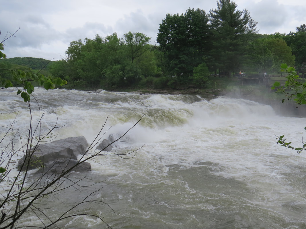
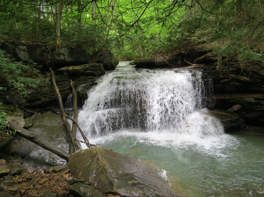
Falls at Ohiopyle on the Youghiogheny River.
|
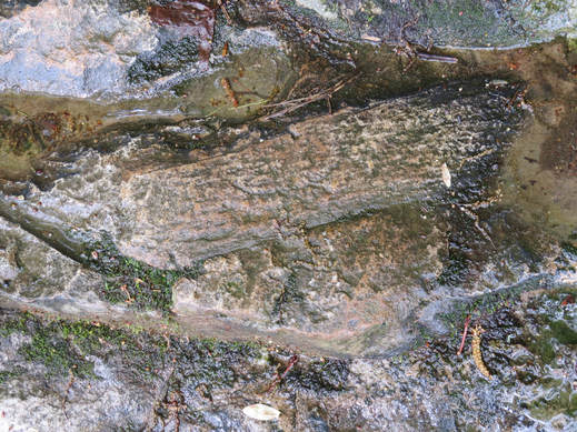 Fossils provide evidence of what Pennsylvania used to be like 300 million years ago.
On the hike back from the riverbank, Oscar and I paused at an interpretive sign that described the climate in Pennsylvania 300 million years ago. Turns out it was a tropical swap with ferns that grew 80 feet tall. The proof was in the fossils that were embedded in the rock near the sign. Most of these were plants such as Cordaites leaves and Lepidodendron scales (basically the bark of huge trees). There was also a giant dragonfly fossil in the area, but we did not locate that one.
Once we finished our loop we paused to get our bearings back at the intersection with the rail trail. We had only done a couple easy miles, the weather was looking good and it was still early so we figured the day was good for a little more hiking. We continued west on the rail trail, across the high bridge where we got some nice views of the river which was now well below us. We stopped for a snack at the intersection with the Great Gorge Trail. There was a convenient bench in a wide spot along the trail at this point, so a good place for a break. We watched the traffic on the trail as we had our lunch. Not many other folks out today, just a handful of bikers and even fewer hikers. Referring to the map, it seemed that the Great Gorge Trail would take us to the Kentuck Trail and finally the Jonathon Run Trail which is where the waterfalls that Chris wanted to see were located. OK, that looks to be in the 5-mile roundtrip range with some mild elevation change, but everyone was up for it. Sounds like a plan. We finished our snack and got back on the trail.
Chris and Rhonda were leading the pack as we headed up the Great Gorge Trail. We walked by an intersection in the trail, where I thought we needed to turn right but they stuck to the left, so I called to them asking if we were on the right track. They assured me that we were. OK, we can't get lost so let's just go with it. Worse case is that we'll end up at Cucumber Falls…which we did. But that worked out as this was a very nice hike that took us to a beautiful destination. The trail crossed Cucumber Run then wrapped around to provide access to the falls. There were three kids (teens) exploring in the area behind and below the falls when we arrived but they soon moved on and we had the spot to ourselves. The falls is just a short distance upstream of the point where Cucumber Run drains into the Youghiogheny. The 30-foot high falls pours into a rocky bowl. The trail takes you down to creek-level a little below the falls and there are nice view points for the trail at a couple places on the trail. But to get better angles for photos we got off the trail and climbed over the rather slick bounders scattered about the area. These rocks were slick! Chris almost took a tumble into the creek after slipping and banging his knee.
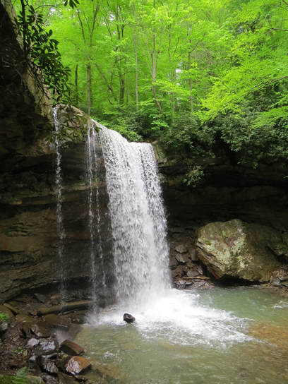 Cucumber Falls
Waterfall photography is one of areas where my simple bridge camera does not measure up to the more complex camera. I just do not have enough range of control to slow the shutter speed and control the aperture to create the silky, flowing effect of the water. I have done it in the past on overcast days, so I thought I might have a shot today, but not quite. Still it was a pretty sight and I got some decent shots. I'll leave the more complex photos to Chris and his DSLR.
After we explored around Cucumber Falls, we reversed course and retraced our steps to the main trail, back across the high and low bridges to the parking lot. Ramblr indicated that we had hiked 5.6 miles, but Oscar's GPS showed 6.6. While there were some ups and downs along our route, this was effectively a flat hike with the elevation variation being only about 100 feet. We were on the trail for about 4 hours. But the rain held off, so it was a good day on the trail. After the hike, we made a quick stop at the general store in Ohiopyle as the ladies were looking for a big frying pan (apparently that is one thing the rental house is lacking). I took advantage of the opportunity to pick up a few trail bars and a bag of peanut butter filled pretzels. We were back at the house, sitting on the porch, beer-in-hand by 3:30. I was just starting to dial the phone when Lynn called to check-in (how's that for telepathy?); all is well.
I stuck with the beers I had brought to start, a Hop JuJu and a Head Hunter, but I did include one of Chris's Commodore Perry IPAs later in the evening. That was the beer that got me hooked on IPAs in the first place all those many years ago.
Donna was again in charge of the kitchen. Tonight was sort of a cook-out, with burgers and brats, but also roasted potatoes and asparagus. Rhonda had brought along Hatch green chilies and there were some other hot peppers available as well. The perfect condiment for, well, everything! I ate way too much, including that slice of cheesecake.
Our topic of conversation for this evening was movies, the best and the worst. We started in the kitchen then moved out to the front porch about 7:30 to enjoy the evening. There were a few deer across the road in the field next to the body shop. The conversation was lively but not as long-lived as last night as we were all heading to bed about 9:30. "We are getting old," was Donna's explanation.
Photo gallery from our hikes along the Ferncliff Loop and to Cucumber Falls.
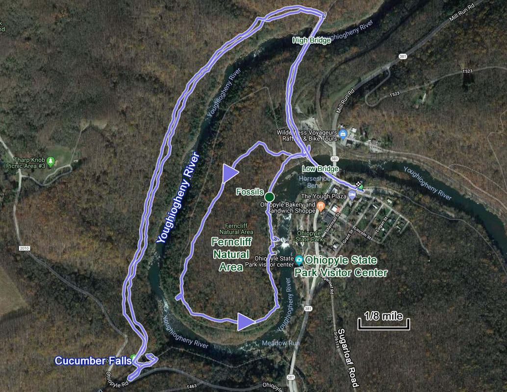
Our hiking route for the first day of our Ohiopyle trip. Around the Ferncliff Natural Area then across the High Bridge and finally along the river to Cucumber Falls. Nice hike.
Friday, May 18 - McCune Trail. Last night the forecast again looked like a total washout for today, but this morning there was no rain. The Weather Channel was showing that we should have a dry window for the morning and into the afternoon. We'll take it. Now the question is, where to hike. While the ladies tended to breakfast the guys studied the maps and the information gathered from the visitor center. We determined that the McCune Trail looked like a nice option as it had the remains of an old homestead and also was advertised to wind through a variety of terrains. This was a trail that the rest of the gang had not hiked. Sounds like a winner.
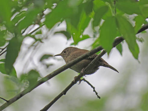 House Wren at the VRBO.
This was Rhonda's morning to run the kitchen and she made her version of eggs Benedict. Quite tasty. We all lounged around the kitchen for a while after breakfast, allowing the coffee drinkers to get their daily dose of caffeine. At some point I wondered out to the front porch. There was a House Wren making its presence known; such a loud and bold call for such a little bird. Even littler was the Ruby-throated Hummingbird that was zipping about.
By 10:00 we were all ready to roll for the hike. North again on route 381 to Ohiopyle then east along Sugarloaf Road (SR 2012) to the trailhead which is near the eastern edge of the park. About a 20 minute drive. I don’t remember passing another car along the way. Good signage to point out the various points-of-interest and trails, but they do not provide a lot of warning, but we found our destination with no problem. Just a couple hundred yards of dirt road to the unpaved parking area. No other cars were in the lot when we arrived, which was good as Oscar's big F-250 requires a few acres to turn around.
Once unloaded from the trucks, we got our packs and checked the trail map. We had hit a sprinkle or two on the drive in, but it seem to be clearing a bit now, so that's a bonus. For whatever reason, we seemed to be doing a lot of milling about the trailhead with not a lot of motion toward the trail, but slowly the gang gathered together. I was closest to the trail so I said "let's go" and headed past the trailhead sign. I hope they are following me.
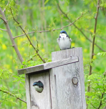 Tree Swallows
Yesterday I was at the back of the pack, where I usually am, taking pictures and looking at the details along the trail. So being out in front provided a different perspective. The nice thing was that the trail was quiet in front of me, so I was getting the first chance of seeing any critters that might be out and about. There were a few, but mostly gone birds. Nothing really wanted to pose for a portrait. The only photo I did get was of a couple Tree Swallows sitting on a bird box in an open field above the trail (I had just zoomed in to get a closer look as they were too far away to identify, but took the photo anyway; I later saw noticed that second bird peaking out from the box).
The trail is open to start but then becomes enveloped in the trails as we continued. There were some interesting wildflowers along the way, which we stopped to study. But the highlight of the hike were the remains of the old homestead, the McCune Farm. Not much left really, the foundations of a few structures, a couple old outhouses, the springhouse and a pond. There was a fair amount of debris scattered about the house sites: coils of rusty barbed wire, dismantled iceboxes, rusted out stoves and heaters, several bottles and a few cans (some were more recent additions, but there was one old Pepsi can with an opening from a pull-top…I have not see one of those since I was a kid). Overall a pretty cool place to explore. The guys were climbing about the site, carefully as there was plenty to get cut or scraped on. The girls stayed on the trail, which was above the ruin site. We probably played around here for about 30 minutes, give or take a little. Funny thing was that while we were out here at the old homestead, I got a call from Lynn. Shocked that I had signal, but she was coming through loud and clear. She is on her way from Lisa's to join us for the remainder of the weekend. Groovy, at least she'll get some time to visit with the gang.
The trail is open to start but then becomes enveloped in the trails as we continued. There were some interesting wildflowers along the way, which we stopped to study. But the highlight of the hike were the remains of the old homestead, the McCune Farm. Not much left really, the foundations of a few structures, a couple old outhouses, the springhouse and a pond. There was a fair amount of debris scattered about the house sites: coils of rusty barbed wire, dismantled iceboxes, rusted out stoves and heaters, several bottles and a few cans (some were more recent additions, but there was one old Pepsi can with an opening from a pull-top…I have not see one of those since I was a kid). Overall a pretty cool place to explore. The guys were climbing about the site, carefully as there was plenty to get cut or scraped on. The girls stayed on the trail, which was above the ruin site. We probably played around here for about 30 minutes, give or take a little. Funny thing was that while we were out here at the old homestead, I got a call from Lynn. Shocked that I had signal, but she was coming through loud and clear. She is on her way from Lisa's to join us for the remainder of the weekend. Groovy, at least she'll get some time to visit with the gang.
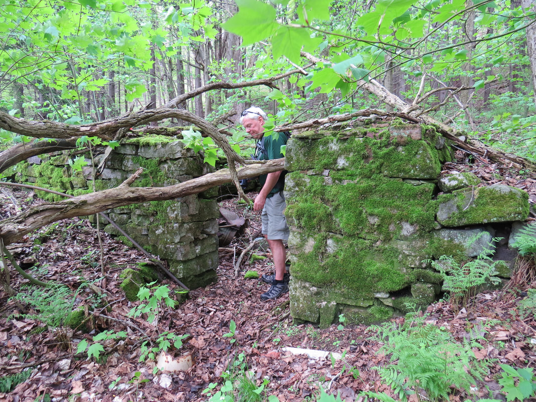
Oscar checking out the old farm house.
|
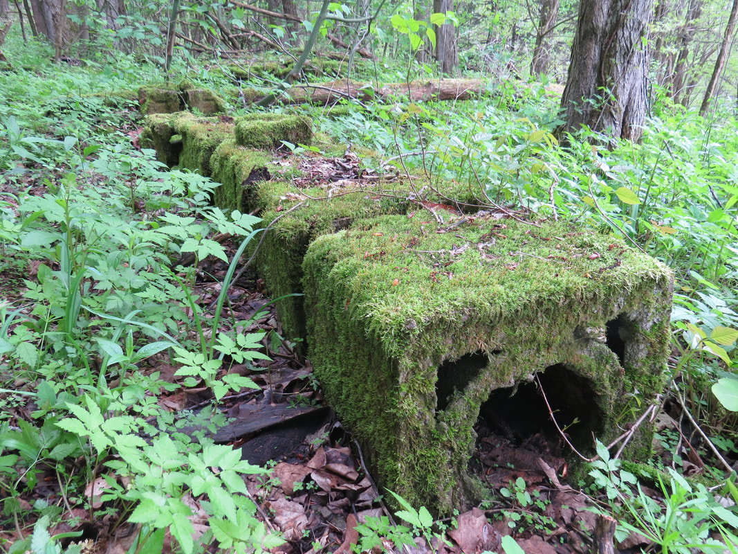
Guessing this is a fallen chimney from one of the houses.
|
Donna's leg was bothering her, so she was thinking about heading back to the trucks to wait for us. We made a quick check of the map and confirmed that we were less than half-way through the loop with the steep sections yet to come, so, yeah, this would be the time for her to turn back. Carol went with her. The rest of us continued along the loop.
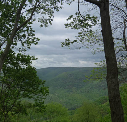
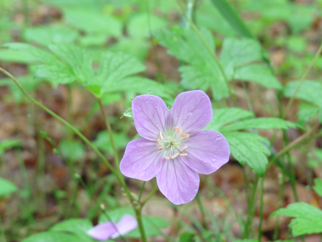
There was a nice view out over the valley containing the Youghiogheny River at the point where the trail starts to loop back and just before it starts to climb (not a huge climb at about 400 feet gain over roughly 0.6 miles, but a bit on the steep side; but I was still breathing hard). While we were taking in the view, we met the only other folks that we would see on the trail, three mountain bikers who like us were also working their way clockwise around the loop. Turns out that the uphill section was tough on bikers as well, since one of them was pushing their machine of the slope. In additional to the elevation gain, the character of the trail and the landscape had changed, becoming more rocky. There were several huge boulders and rock outcroppings in the area. We also spotted some interesting flowers, including what looked like a deep red trillium and a bi-color, white with pink-center trillium.
Once up the slope and through the rocks, we found a spot for a break and a snack. Rhonda had again provided a peanut butter and honey sandwich for me. Then we continued around the loop, loosing most the elevation we had gained over the last half-mile on the trail. Donna and Carol were waiting patiently for us; having spread a blanket on the ground between the trucks. There were a couple other vehicles in the lot when we arrived, all mountain bikers according to Donna.
Photo gallery from the McCune Trail hike.
After a short break, we loaded in the trucks and continued east on Sugarloaf Road, looking for the fire tower. Chris and Oscar recall stopping at one during their last visit and taking in the views, but they were not sure were it was located. There was one marked on the map just a short distance up the road. We decided to check this one out since it was close by. At least that was the theory. We turned left onto Fire Tower Road (the road name was a good sign at least) and the tower should have been not far off the main road according to the map. We did not see it nor any place that would have afforded a grand view, so we kept driving….and driving… and the road just got rougher and rougher. Eventually, the area on either side of the road was posted as private property, so we knew we had exited the park. That's when we decided it was time to do an about face. But we did have one interesting view, actually two as we saw it coming and going along the road. There was a large, grey bird of prey swooping through a rather thick area of the forest. It was moving too quickly and disappeared into the foliage before we could get a good look, but our best guess is an owl of some sort, probably a Great Horned, but there is no way to know for sure.
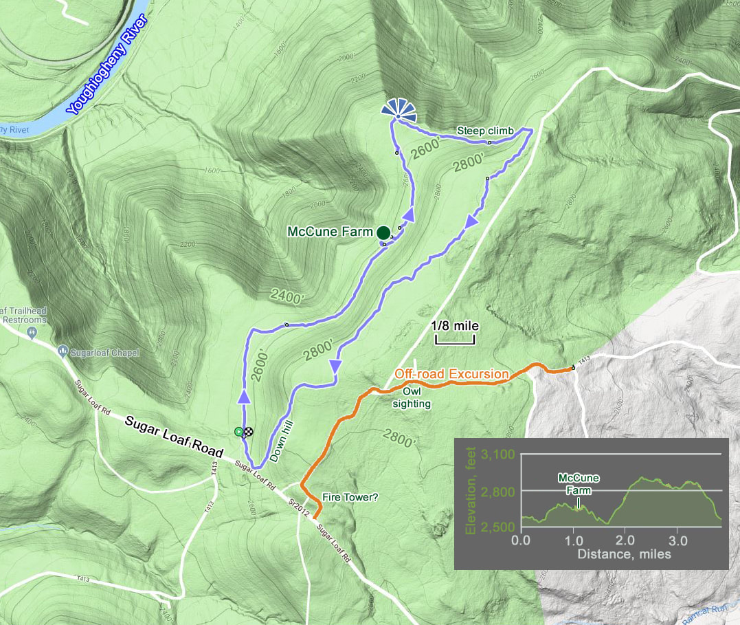
The McCune Trail hike and the route of our off-road adventure.
Since we struck out on the fire tower we figured it was time to head home. By now we were far enough east that the navigation system in Oscars truck just had us continue east out of the park to route 281, then south to route 40 west, so basically we were just making a loop drive. That worked as we needed to buy some ice so this put the convenience stores right on our way home (convenient, right!). The bonus in going this route is that we passed by the parade of horse-drawn wagons and buggies pulling out onto route 40. Must have been part of some festival or something. Cool to see.
We completed our quick stop for ice and were home about 3:00. Lynn was waiting for us, already perched on the front porch, beer in hand. That's my girl! The rest of the gang followed her lead, although the drink of choice varied from beer to wine depending on the drinker. Oscar, Chris and I sampled a variety of brews that we had brought with us: Fat Head's Hop JuJu, Lager Heads Flanders Red, Saison du Buff from Dogfish Head, The Train I Ride Triple IPA from Clown Shoes and Red Sky at Morning farmhouse ale from Heavy Seas topped the list. We heard some turkeys off in the distance and spotted the first hummingbird of the season checking out the feeder handing at the corner of the porch.
Carol was in charge of dinner tonight. She made shrimp curry which was excellent. After dinner we continued our chatting in the kitchen. The topic for tonight was favorite hiking trail. Then we adjourned to the living room for the first and only time to watch Chris's slideshow from their 2017 Santa Fe trip. He is a great photographer. But I think I nodded off for the last few minutes.
Saturday, May 19 - Kentuck Trail. I rolled out of bed at 0615 and got ready for the day. I was downstairs about 0730. Carol was scurrying about the kitchen making pancakes. I guess I heard "polenta" but it did not register, so I was a little surprised to find that the lumps in the cakes were corn. Sort of cornbread pancakes. Works for me. Very tasty!
We were geared up for another day of hiking by 9:30. We had decided to take the Kentuck Trail down to the Jonathon Run Trail to see the waterfalls. Donna was out for hiking today as her hip was bothering her; Rhonda stayed home as well. We're thinking there will be several empty wine bottles by the time we get back. The rest of us loaded into Oscar's F-250 and headed to the park.
The weather again cooperated even though the review of the forecast last night looked like an all-day soaker. But this morning the skies were actually clearing a bit. Looks like a great day for a hike. We were at the Kentuck trailhead near the campground just after 10:00 following a detour down the camp ground road where a Boy Scout troop was drying tents and equipment.
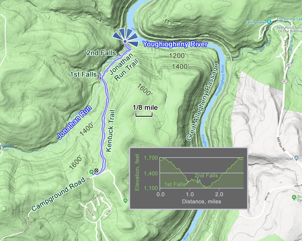
As I mentioned when we visited the Ohiopyle State Park Visitor Center on the first day in the park, the Jonathan Run Trail was closed due to "all the bridges" being out (that's what the guy at the visitor center said; no idea how many bridges are included in "all"). The alternative route was to take the Kentuck Trail down to the Jonathan Run Trail as these trails connect below the area where the bridges are missing, then continue along Jonathan Run to access the waterfalls. That's the plan. And it worked, albeit there was a bit of work required to get good access to the falls.
The Kentuck trail is a steady downhill track from just below the campground to the intersection with Jonathan Run. Just an easy walk through the woods. Not an overly wide trail but in pretty good shape. We did see the evidence of the heavy rains that came through last night as there plenty of leaves and other forest debris collected along the edge of the trail, deposited by the run-off of the deluge. The intersection of the trails is right above a falls area and we found a narrow trail that snaked down to the edge of the creek and provided nice views of the little falls. Speaking of snakes, Oscar nearly stepped on one when he got to the bank of Jonathan Run, a little greenish, water snake that swam off under the rocks. Chris, Oscar and I spent the next several minutes hopping about on the rocks to get some photos of this initial fall, then worked further downstream to access the next little fall. Hey, look, there's a millipede; I've seen a couple of these along the trails this weekend. There was a display that included these bugs at the visitor center, so maybe that tuned me into them. I thought the example was identified as a hellgrammite but looking at information from the web now after the trip it seems that this is a millipede and a hellgrammite is different looking, multi-legged varmint.
Lynn and Carol had only come part-way down the narrow access trail and eventually went back up to the Jonathan Run Trail to wait for us. We all reconvened on the main trail and continued downstream looking for the next waterfall which was near to the end of the trail. As we started down the trail, I spotted a moth sitting on a leaf next to the trail and was able to get a decent photo that turned out to be good enough for an identification by the experts at www.butterfliesandmoths.org: Oak Besma (Besma quercivoraria)
We completed our quick stop for ice and were home about 3:00. Lynn was waiting for us, already perched on the front porch, beer in hand. That's my girl! The rest of the gang followed her lead, although the drink of choice varied from beer to wine depending on the drinker. Oscar, Chris and I sampled a variety of brews that we had brought with us: Fat Head's Hop JuJu, Lager Heads Flanders Red, Saison du Buff from Dogfish Head, The Train I Ride Triple IPA from Clown Shoes and Red Sky at Morning farmhouse ale from Heavy Seas topped the list. We heard some turkeys off in the distance and spotted the first hummingbird of the season checking out the feeder handing at the corner of the porch.
Carol was in charge of dinner tonight. She made shrimp curry which was excellent. After dinner we continued our chatting in the kitchen. The topic for tonight was favorite hiking trail. Then we adjourned to the living room for the first and only time to watch Chris's slideshow from their 2017 Santa Fe trip. He is a great photographer. But I think I nodded off for the last few minutes.
Saturday, May 19 - Kentuck Trail. I rolled out of bed at 0615 and got ready for the day. I was downstairs about 0730. Carol was scurrying about the kitchen making pancakes. I guess I heard "polenta" but it did not register, so I was a little surprised to find that the lumps in the cakes were corn. Sort of cornbread pancakes. Works for me. Very tasty!
We were geared up for another day of hiking by 9:30. We had decided to take the Kentuck Trail down to the Jonathon Run Trail to see the waterfalls. Donna was out for hiking today as her hip was bothering her; Rhonda stayed home as well. We're thinking there will be several empty wine bottles by the time we get back. The rest of us loaded into Oscar's F-250 and headed to the park.
The weather again cooperated even though the review of the forecast last night looked like an all-day soaker. But this morning the skies were actually clearing a bit. Looks like a great day for a hike. We were at the Kentuck trailhead near the campground just after 10:00 following a detour down the camp ground road where a Boy Scout troop was drying tents and equipment.
As I mentioned when we visited the Ohiopyle State Park Visitor Center on the first day in the park, the Jonathan Run Trail was closed due to "all the bridges" being out (that's what the guy at the visitor center said; no idea how many bridges are included in "all"). The alternative route was to take the Kentuck Trail down to the Jonathan Run Trail as these trails connect below the area where the bridges are missing, then continue along Jonathan Run to access the waterfalls. That's the plan. And it worked, albeit there was a bit of work required to get good access to the falls.
The Kentuck trail is a steady downhill track from just below the campground to the intersection with Jonathan Run. Just an easy walk through the woods. Not an overly wide trail but in pretty good shape. We did see the evidence of the heavy rains that came through last night as there plenty of leaves and other forest debris collected along the edge of the trail, deposited by the run-off of the deluge. The intersection of the trails is right above a falls area and we found a narrow trail that snaked down to the edge of the creek and provided nice views of the little falls. Speaking of snakes, Oscar nearly stepped on one when he got to the bank of Jonathan Run, a little greenish, water snake that swam off under the rocks. Chris, Oscar and I spent the next several minutes hopping about on the rocks to get some photos of this initial fall, then worked further downstream to access the next little fall. Hey, look, there's a millipede; I've seen a couple of these along the trails this weekend. There was a display that included these bugs at the visitor center, so maybe that tuned me into them. I thought the example was identified as a hellgrammite but looking at information from the web now after the trip it seems that this is a millipede and a hellgrammite is different looking, multi-legged varmint.
Lynn and Carol had only come part-way down the narrow access trail and eventually went back up to the Jonathan Run Trail to wait for us. We all reconvened on the main trail and continued downstream looking for the next waterfall which was near to the end of the trail. As we started down the trail, I spotted a moth sitting on a leaf next to the trail and was able to get a decent photo that turned out to be good enough for an identification by the experts at www.butterfliesandmoths.org: Oak Besma (Besma quercivoraria)
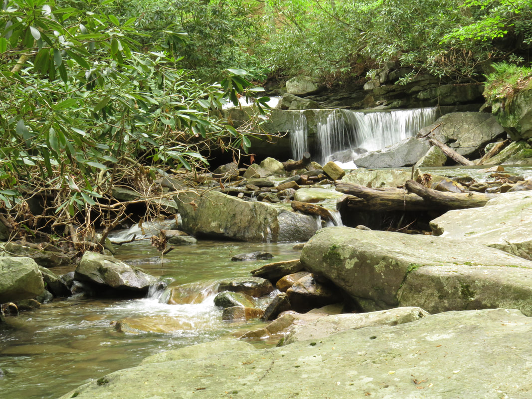
This is the little waterfall just below the first falls we came to (that one is shown in the photo at the top of this page).
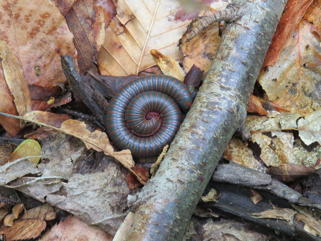
Millipede
|
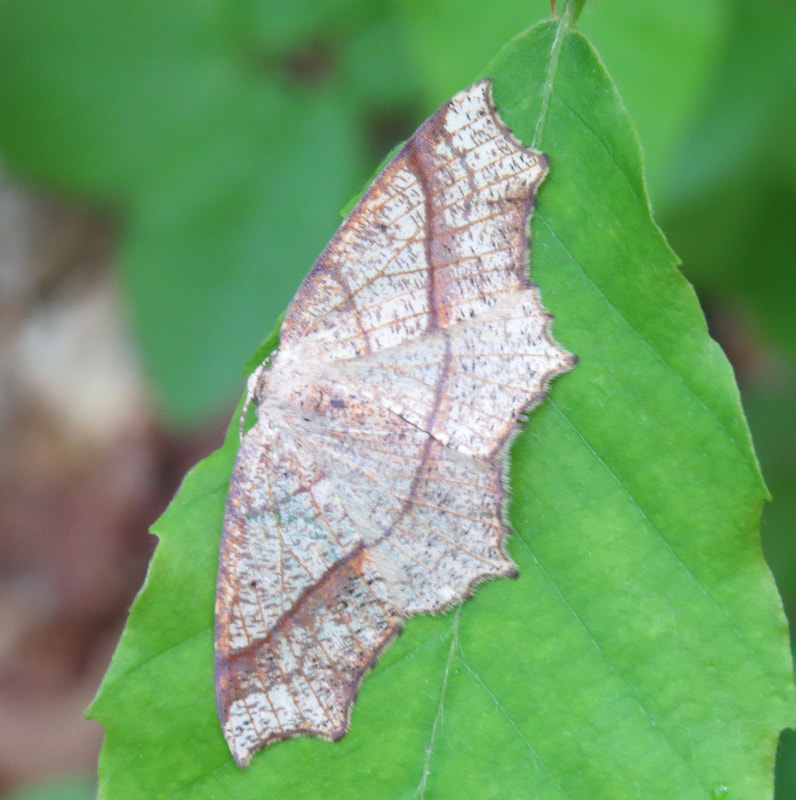
Oak Besma (Besma quercivoraria)
|
The second, larger falls is about 0.3 miles downstream from the intersection of the Kentuck and Jonathan Run Trails. But access to the larger falls is much more of a challenge. Where the first falls was only 20 feet or so below the trail, the larger falls was probably close to 100 feet down in the gorge. We spotted the access trail that worked down the steep side of the gorge and gave it a look. The first section was easy enough, working through a couple switchbacks, but then it turned straight down the nearly vertical slope. Fortunately, a rope had been setup here and strung around a couple of well placed trees to provide a means to get up and down the slope. But the rains from last night had made this section a muddy mess and quite slick. But we're here now, so let's give it a while. Getting down the slope was fairly easy, just had to find the good footing. Gravity was on our side going this direction.
Chris, Oscar and I again spent a while bouncing around on the rock below the falls getting some photos. A pair of twenty-something guys in flip-flops and Crocs joined us a few minutes later (we had seen these guys on the Jonathan Run Trail hiking upstream, so they must have missed the access trail on their first pass). They were a little annoying as they just seemed oblivious that we are trying to get some decent photos. One of the guys stepped into Oscar's field of view, realized what he had done then asked if Oscar was taking a photo. Oscar replied, "no, I'm just holding a camera." The kid moved out of the frame.
Again, my superzoom did not quite have the range of aperture and shutter speed to get the flowing effect, but I still got some decent shots. Chris on the other hand got some lovely images of the falls.
Once we got our shots and enjoyed the views from below the falls, we had to make the climb back up to the main trail. Easier said that done. The good news is that Oscar remembered that he had gloves in his pack, left there from his climb up Half Dome in Yosemite. Chris also had some winter gloves, not has good for the rope as Oscar's but better than nothing. Once Oscar got up the rope, he tossed his gloves down to me. His aim was off as the first glove sailed to the far side of a huge log along the slope, so I had to scramble under the log to retrieve the wayward glove. But the second was on target. The gloves made all the difference in getting back up the greasy gorge wall.
Lynn and Carol were waiting for us on the Jonathan Run Trail. We continued on to the end of the trail, where it connects with the Greater Allegheny Passage. Nice views from the old railroad bed of the Youghiogheny River. We paused here for a snack. We could see that the sun had actually broken through the clouds and there were large patches of blue sky showing behind the fluffy, white clouds. A nice change from the grey overcast we have had the past few days. Seems the improved weather has brought out a few more bikers on the trail as well. We finished our nut bars and trail mix then retraced our steps back up the Jonathan Run and Kentuck Trails the our starting point. We loaded into the truck and were off in search of our next adventure.
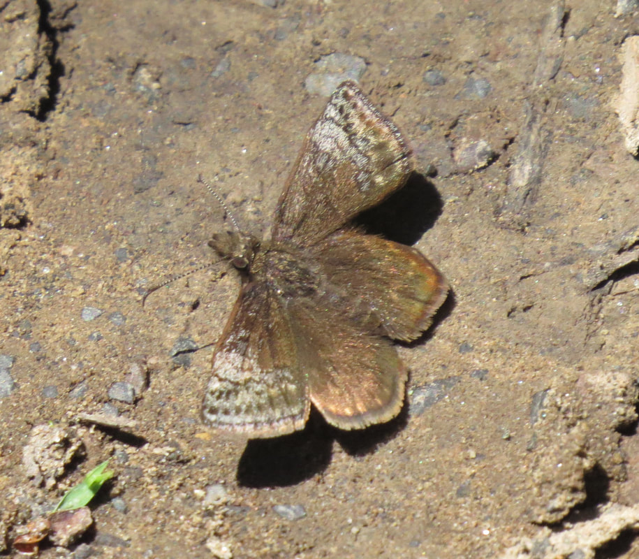
We decided to take a look a the fire tower marked on the map just down the Campground Road; maybe this was the one that Chris and Oscar remembered. We parked at the wide spot along the fire tower access road, just a little ways short of the gate that blocked vehicle access to the fire tower. As it was just a short walk up to the fire tower and helipad, I opted to leave my pack in the truck and just grabbed my camera and a water bottle the later fitting nicely in the large pocket of my cargo shorts. And we are off. Just an easy stroll up the looping driving that gradually climbed to the bald nob with the old fire tower. The road is exposed and as we got to the top opened to provide a nice view of the surrounding area. Lynn spotted some turkeys making a short flight from the open area along the road into the cover of the trees. The driveway looped us right past the fire tower which was sitting quietly. No one was around. While I would not call it abandoned, it certainly was in need of some love. There were a couple of huge hornet nests under the eaves of the building and looking through the windows it was apparent that there leaks in the roof as the ceiling tiles were severely stained. But there were maps on the walls of the building, so it was probably still used as a command post if there were fires in the area. But we came up here to the top of this bald nob for the view and Our timing was right as the sky was continuing to clear, but still had plenty of big white clouds to add interest and contrast to the green of the rolling hills. We enjoyed the vista a bit, took a closer look at the fire tower then walked back down the road to the truck. There were several little butterflies flitting about the area, interested in the puddle next to the F-250. I managed to get a photo of one, sort of a nondescript little blackish critter with some light spots. We'll see if the experts and figure this one out as I could not (they did: Dreamy Duskywing (Erynnis icelus).
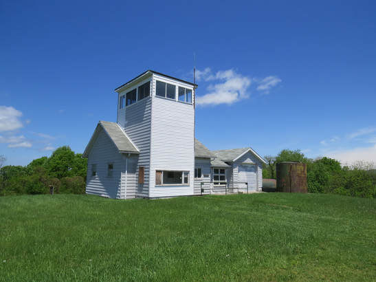 The fire tower along the Ohiopyle Campground Road.
Here are the photos from the Kentuck Trail hike and our walk to the fire tower.
Talk about dodging a weather bullet! All three days have been great for hiking and today is gorgeous. Blue sky and 80 F this afternoon. The forecast is still calling for thunderstorms to roll through later this evening but that should not bother us as we'll be home on the porch by then. And home was our next stop; we were back at the house about 2:00.
The guys ended up on the porch going through photos from today's hikes. Chris gave Oscar and me some pointers on getting the most out of our cameras for the waterfall shots. He advised using a neutral density filter to adjust the F-stop to the point where we could open the aperture more and get that silky effect. This idea is to get the shutter speed to about a quarter second, that was what he was using for the shots today (I think the best I could get was 1/20 of a second). A polarizing filter would also do the same thing, but an ND would be better. Chris suggested a ND filter in the 3 or 4 stop range. I will definitely give this a try.
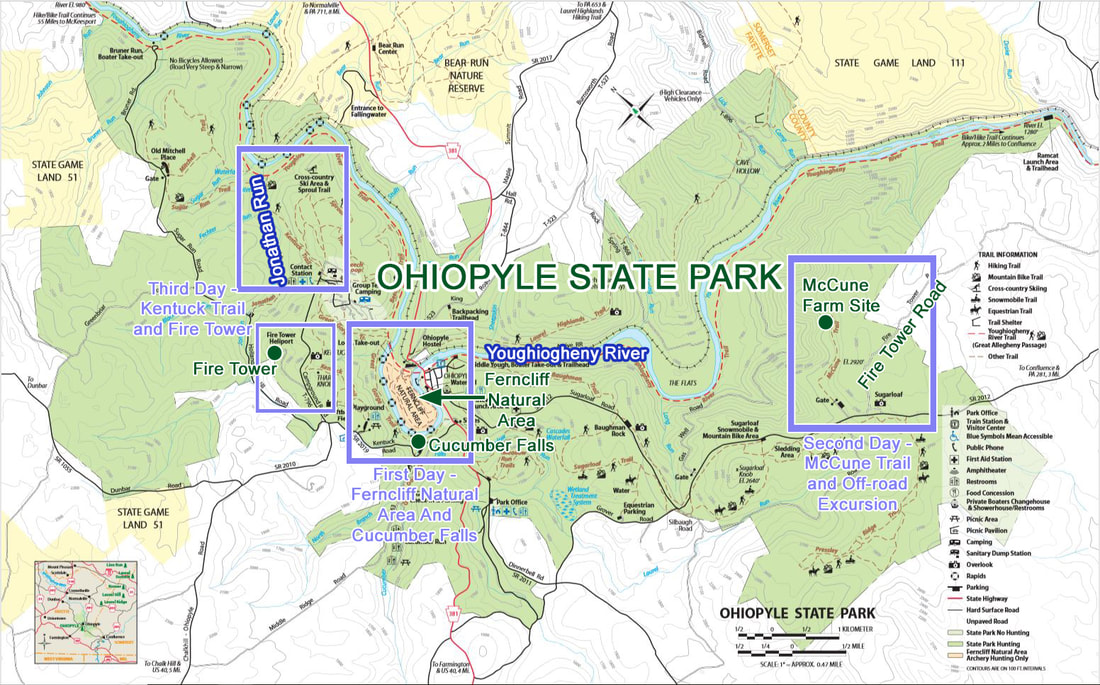
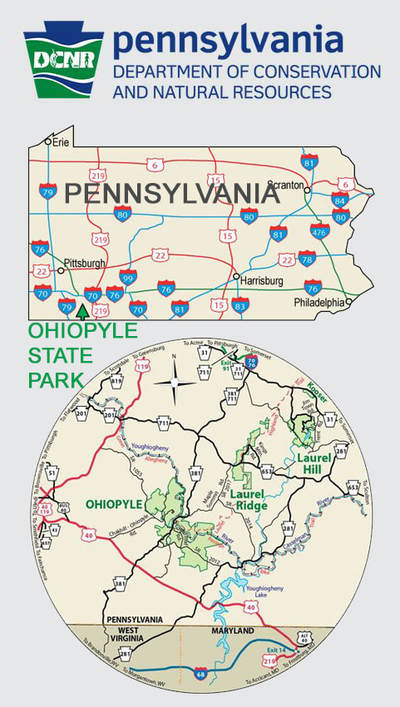
Ohiopyle State Park map showing the areas we explored. Click the map for a larger version.
At some point during the afternoon, I walked around the house. We had noticed some structures only the tree line on the hill behind the house, so I zoomed the camera in to get a closer looked. Targets. One looks like a deer and there's and elk. Also a small cemetery right at the edge of the treeline up on the hillside, probably a family plot.
Rhonda was chief chef tonight and made sesame chicken. Another great meal. I mentioned that old graveyard and suggested that might make a nice after dinner stroll, not really thinking that anyone would take me up on the idea. They did. So a little before 7:00, Chris, Rhonda, Oscar and I headed out the back door and out along the path ways cut into the field. Lynn followed us a little bit later. Turns out there were targets scattered all through the field and several paths crisscrossing the area. Looks like a shooting club. But no one was out this evening so I think we are safe. We made our way across the field and up the hill to the tree line then worked across to the small cemetery that was set back in to the woods. Most of the headstones were from the Van Sickle and Griffin families. The oldest stones were worn to the point of being unreadable. The oldest dates we could read were from the early 1800s; the most recent we saw was 2006. Some long lived folks with the oldest being 104, but also may children, one list as one day old. Several GAR markers. One gentleman had served with the 6th West Virginia Cavalry during the Civil War. Plus we had a great view looking out over the bucolic countryside from this perch up on the hill. The only downside to this little trek was that we found that poison ivy was mixed in with the grass on our walk back through the field, so we all had quick showers to avoid any itching later. Then we reconvened on the front porch for one more evening chatting away until almost 10:00.
Rhonda was chief chef tonight and made sesame chicken. Another great meal. I mentioned that old graveyard and suggested that might make a nice after dinner stroll, not really thinking that anyone would take me up on the idea. They did. So a little before 7:00, Chris, Rhonda, Oscar and I headed out the back door and out along the path ways cut into the field. Lynn followed us a little bit later. Turns out there were targets scattered all through the field and several paths crisscrossing the area. Looks like a shooting club. But no one was out this evening so I think we are safe. We made our way across the field and up the hill to the tree line then worked across to the small cemetery that was set back in to the woods. Most of the headstones were from the Van Sickle and Griffin families. The oldest stones were worn to the point of being unreadable. The oldest dates we could read were from the early 1800s; the most recent we saw was 2006. Some long lived folks with the oldest being 104, but also may children, one list as one day old. Several GAR markers. One gentleman had served with the 6th West Virginia Cavalry during the Civil War. Plus we had a great view looking out over the bucolic countryside from this perch up on the hill. The only downside to this little trek was that we found that poison ivy was mixed in with the grass on our walk back through the field, so we all had quick showers to avoid any itching later. Then we reconvened on the front porch for one more evening chatting away until almost 10:00.
View from the cemetery.
Photos from our time around the rental house.
Sunday, May 20 - Fort Necessity, lunch with Lisa then home. I was up and out of bed about 6:15; I had been catnapping since about 5:00. Lynn and I were to provide breakfast this morning and our plan was to just pick-up some muffins or something at the bakery in Ohiopyle, if needed. I confirmed with Donna last night, and as I suspected there were plenty of leftovers from the previous three mornings to feed us and the rest of Farmington, so no need to add any more to the mix. Folks just fended for themselves this morning. I scraped together a banana, bagel and a slab of the Cowboy Casserole. Can't let it go to waste (although it will now to go waist!).
Sunday, May 20 - Fort Necessity, lunch with Lisa then home. I was up and out of bed about 6:15; I had been catnapping since about 5:00. Lynn and I were to provide breakfast this morning and our plan was to just pick-up some muffins or something at the bakery in Ohiopyle, if needed. I confirmed with Donna last night, and as I suspected there were plenty of leftovers from the previous three mornings to feed us and the rest of Farmington, so no need to add any more to the mix. Folks just fended for themselves this morning. I scraped together a banana, bagel and a slab of the Cowboy Casserole. Can't let it go to waste (although it will now to go waist!).
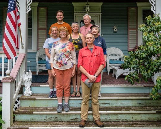
After breakfast the gang set to packing and getting the place in order to leave. Busy like a little herd of ants. Everyone pitched in and we were all ready to get on the road at 9:30. The odd sighting in the yard this morning was a good size, bright orange crawdad just walking through the yard. No idea where he came from or where he was going. One theory was that maybe it had been snatched up my a bird and then dropped in our yard. Who knows. But it was one a mission to get somewhere. And it was a tough little guy as it would rear up and show its claws if anyone got too close. Oscar took him over to the little pond across the road. Before heading out, we gathered the group for a team photo on the front steps of the house. Then it was hugs and handshakes…OK, mostly hugs. We were pulling out of the driveway at 0945.
Looks like a beautiful day is on tap. The overcast is gone. The sky is bright blue with big white clouds scattered about. Donning my Maui Jim's, I am ready to drive. Lynn and I made a few stops as we made our way through Pennsylvania and Ohio to get home. First we made a quick stop at the state park entrance sign for our obligatory passport photo, then continued on to the little berg of Ohiopyle for a quick cruise around the town.
Next was Fort Necessity National Battlefield Park, the entrance to which was a very short distance east on route 40 from the intersection with route 381. This is actually a two-for-one National Park site as the visitor center contains information about the battle around Fort Necessity as well as the history of the National Road. We stopped at the information desk to talk with the most heavily-adorned Park Ranger I have ever met; nose ring, large ear-lobe loops, variety of tats on his arms and sporting a Mohawk. This is the very definition of not judging the book by its cover. He was a younger fellow, but very friendly, helpful and knowledgeable. He gave us the run down of what to see and do in the park. Due to time constraints, we opted to skip the 20-minute overview movie, and instead took a spin through the museum which provided the history of the battle then rolled right into the discussion of the National Road.
I remember bits of this period of history from school, but had never studied it beyond that time (my interest was more in the American Civil War). But just going through the displays in the visitor center and out on the battle field have piqued my interest. Perhaps this is due to the fact the campaign that led to and the battle here at Fort Necessity were really the start of the events that led to the American Revolution and the beginning of the United States of America. Here's sort of the sort story, taken from the park brochure and the signage in the museum and out on the field:
The root of the conflict is tied to the British and French trying to expand their control in North American as well as around the globe. Both the French and English claimed vast tracts of land in the Ohio Valley between the Appalachian Mountains and the Mississippi River and neither was going to back down. This all came to a head about 1750. In 1748, the Ohio Company was formed by a group of Englishmen and Virginians looking to develop the economic potential of the region.
The French on the other hand were also interested in the area as they saw the Ohio Valley as a crucial link between Canada and Louisiana. Governor Robert Dinwiddle of Virginia learned of French advances into the Ohio Valley including the building of several forts along the Great Lakes and the Ohio River. In January 1754, the Governor sent a small force of Virginian soldiers to build a fort at the forks of the Ohio River, where Pittsburgh now stands. The stockade was just finished when a French force drove the Virginians away and built a large fort on the site. The French named this Fort Duquesne.
In early April, Lt. Colonel George Washington felt Alexandria with part of a regiment of Virginia frontiersmen to build a road to Redstone Creek on the Monongahela River the help defend the fort on the Ohio. When Washington learned that the fort was in French hands, he moved on to Redstone Creek and there awaited further orders. He was well beyond Wills Creek when joined by the rest of the regiment commanded by Col. Joshua Fry around the end of May.
Washington arrived at the Great Meadows on May 24. While the meadow was mostly marsh, Washington thought it "a charming field for an encounter" and had his men setup camp. Three days later, Washington learned that French soldiers had been seen about seven miles away on Chestnut Ridge so he and 40 men set out to locate the French troops. On May 28, with help of friendly Seneca Indians led by their chief known as Half King, who knew where the French troops were camped, Washington and his men surprised the 33-man French force. Ten were killed, including commander Joseph Coulon de Viliers, Sieur de Jumonville, one wounded and 21 taken prisoner. One man escaped and carried the news back to Fort Duquesne. The British lost one man with two wounded. It was reported that the Seneca Chief Half King killed Jumonville.
Washington took command of the regiment on May 31 following the death of Col. Fry at Wills Creek. Fearing attack, Washington had his men fortify their position in the Great Meadows. By June 3, the circular palisaded fort, named Fort Necessity by Washington, was complete.
The rest of the Virginia Regiment arrived at the Great Meadows on June 9, bringing supplies and nine swivel guns. Washington now commanded 293 officers and men. A few days later he was reinforced by a around 100 regular British troops from South Carolina commanded by Captain James Mackay. Unfortunately, Washington could not retain his Indian allies.
Washington spent much of June having his Virginians building a road from Fort Necessity to Gist Plantation in the direction of the forks of the Ohio. He learned that a large force of French and Indians was advancing from Fort Duquesne and withdrew his man to the Great Meadows. On July 2 Washington's men strengthened the defenses of Fort Necessity by digging trenches around the outside of the stockade.
On the morning of July 3, about 600 French and 100 Indians approached the fort, fired several volleys and took up positions in the woods. During the ensuing battle both sides took heavy casualties but the British suffered greater losses. The day had dawned under grey skies and a light rain but by afternoon there was a downpour such that the British troops were lying in water-filled trenches with wet powder and fouled muskets. Fighting continued sporadically throughout the day and into the evening until around 8:00. At that time, Captain Louis de Villiers, brother of Jumonville and commander of the French forces, requested a truce to discuss surrender of Washington's command. Following several hours of negotiations, the terms were put in writing and signed by Washington and Mackay about midnight. The British were allowed to withdraw with the honors or war, retained their baggage and weapons but had to surrender their swivel guns.
An interesting note that occurred as part of the negotiations. As it seemed that the British were getting very positive terms in the surrender, Washington demanded that the terms be put into writing. However, due to the rain that was falling the written French terms were nearly unreadable and were poorly translated from French to English by one of Washington's officers. It was not until later that Washington learned that part of the terms of the surrender was that Washington was to take responsibility for the assassination of Jumonville.
The battle at Fort Necessity marked not only the beginning of the French and Indian War but also a global conflict between Great Britain and France called the Seven Years War. Great Britain and France were the superpowers of the time and were vying for colonies n North America, Asia, Africa, the Caribbean and the Philippines. Both countries built alliances through trade and treaties with the Indians in North America. The war ended in 1763 with British domination over the French colonies.
In 1765, the British parliament levied the Stamp Act in an attempt to pay for the French and Indian War (this was a tax on all printed material in the American colonies). This set the stage for the American Revolution and forever changed the lives of the Native Americans and the colonists.
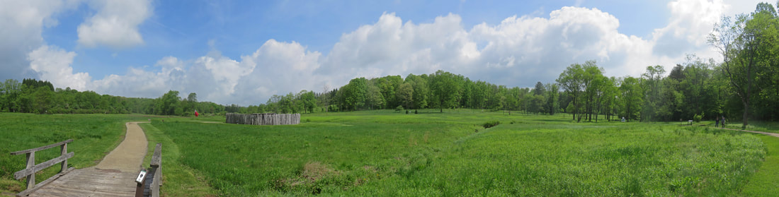
View across the Great Meadow with the reconstructed Fort Necessity.
We walked through the small fort and spoke briefly to the Ranger stationed on the battlefield. He pointed out a few of the key points about the battle as well as the trail leading to the Mount Washington Tavern. Oddly, he suggested that we drive to the Tavern rather than walk as the trail is slightly uphill and it is getting hot. Dude, really? That looks like maybe a long par-5 from here to the tavern on a paved path; an easy walk.
The signage at the tavern provided some insight on the National Road and the tavern:
The "National Road: connected east and west in the 1800s. George Washington proposed a route to join the western frontier to the eastern seaboard in the late 1700s. His idea was later promoted by Albert Gallatin, Secretary of the Treasury under Presidents Thomas Jefferson and James Madison. Congress authorized the road in 1806.
Work started in 1822. While a privately funded road connected Baltimore to Cumberland, Maryland, this first federally funded highway tied Cumberland to Wheeling, Virginia, in 1818. By 1839 the road stretched more than 600 miles to Vandalia , Illinois. Although railroads eventually displaced it, the National Road's success set the stage for today's national highway system.
The Mount Washington Tavern was built by Judge Nathaniel Ewing of Union town about 1930. In 1840, Ewing sold the tavern to James Sampey who then ran the tavern with his family. The tavern was a stage stop for the Good Intent Stage Line, one of many stage lines using the National Road. This was one of the finer taverns along the road, catering to stagecoach passengers. Once inside, travelers cleaned up from their long day's trip then ate a hot meal in the dining room. Later, the women gathered in the parlor while the men congregated in the barroom. There were no private bedrooms. Mend and women slept in separate rooms, usually fully clothed, and sometimes in shared bed space. Often awakened before 5 AM, then continued on their journey. Outside the Mount Washington Tavern stood a stable, shed and other outbuildings. The taverns' stables provided fresh teams of horses for the Good Intent Stage Line. These stagecoaches were pulled by a team of four horses; the teams were changed every 10 to 15 miles during their 60- to 70-mile trip each day.
A placard in the visitor center notes that "for more than 30 years, the National Road fueled the growth of a nation. But by the mid-1800s, the federal highway was beginning to outlive its usefulness. Railroads emerged as major competitors in the transportation business. They hauled goods and people over long distances faster and cheaper than plodding wagons and stagecoaches. In 1842, the Baltimore and Ohio Railroad laid down tracks from Baltimore to Cumberland. Eleven years later, the line extended out to Wheeling, taking most of the National Road business with it. Road traffic slowed to a trickle. Businesses closed. Towns withered. But the old highway did not die out completely. The wheels of progress continued to turn with the promise that glory would one day return."
A placard in the visitor center notes that "for more than 30 years, the National Road fueled the growth of a nation. But by the mid-1800s, the federal highway was beginning to outlive its usefulness. Railroads emerged as major competitors in the transportation business. They hauled goods and people over long distances faster and cheaper than plodding wagons and stagecoaches. In 1842, the Baltimore and Ohio Railroad laid down tracks from Baltimore to Cumberland. Eleven years later, the line extended out to Wheeling, taking most of the National Road business with it. Road traffic slowed to a trickle. Businesses closed. Towns withered. But the old highway did not die out completely. The wheels of progress continued to turn with the promise that glory would one day return."
|
Changing of the Guard
We hear no more the clanging hoof, And the stagecoach rattling by, For the Steam King rules the traveled world And the old Pike's left to die
|
U.S. Route 40 follows the same route (more or less) as the original National Road.
Lynn was sure that she and I had visited Fort Necessity before but I'm pretty certain I have never been here before. We chatted about this as we walked about the grounds. She finally figured it out that she was here as a kid (school trip) and later with her folks and Lisa.
As we walked back from the tavern, we spotted a large snake sunning itself on the paved trail. I think it was a Northern Black Racer, having just done an identity check on a very similar snake that we spotted along the Chippewa Inlet Trail in Medina. I showed the photos to the Rangers at the visitor center (both Mohawk and "don't walk there" were present) but they were not sure of the ID, so they did what I had done and Googled it. We all concurred that it looked to be a Black Racer.
Here's the photo gallery from our tour through Fort Necessity and Washington Tavern.
Next stop was at Lisa's for a tour since I have not seen her remodel job on the house. Very nice. Then we took her to lunch at Red Robin in Washington. The Ghost pepper burger was amazing.
We made no other stops except for fuel on the turnpike (glad I waited to get back into Ohio as the cost was 40 cents per gallon less than in PA). We were home by 5:15. 66 F and blue sky here. The weather was nice when we left Lisa's but then overcast most of the way up from Pennsylvania, but here at home we were under blue skies and the gage on the Edge read 66 F for the outside air temperature. Just a another lovely day.
By the Numbers:
- 5 Wonderful days for the trip including 3 fun-filled and mostly dry days exploring Ohiopyle State Park.
- 7 great folks in the old house and out on the trails (that includes me; someone must at least think I'm OK or they would have only invited Lynn!).
- We'll call it 556 miles on the Edge, including Lynn's shuttling to Lisa's and back to Ohiopyle.
- 414 photos (after culling, editing and creating panoramics).
- 15.3 miles on the trail.
- No new birds but a butterfly and a moth added to the critter list.
- Way too many calories to count!
- And laughs, lots of laughs!