Red River Gorge, Kentucky - 2021 Mini-meet-up
Red River Gorge, Rogers, KY
Wednesday, June 9, through Sunday, June 13, 2021
Wednesday, June 9, through Sunday, June 13, 2021
The Short Story. This is the fourth mini-meet-up with the east-coast members of the Utah Trip Advisor Herd; Donna and Oscar from New Jersey and Rhonda and Chris from just down the road near Columbus. Good group of folks. And while we have diverse histories, we share a lot of common interests, including a love for the outdoors. This is a low-maintenance, no drama crew and we just always have a good time together.
Other than getting thoroughly soaked on the trail two out of three days, this was a fun little excursion. Shoot, we even had fun getting soaked on the trail. Hey, you just have to roll with whatever Mother Nature decides to dish out on any given day. And that’s OK. We all got to explore the Red River Gorge in Kentucky, an area that was new to us all. Who knew there were so many natural arches outside of Utah? We tallied some good miles on the trails and were treated so lovely views, fascinating geologic formations and a few interesting critter sightings. Plus we just had a nice visit with our hiking buddies, along with too much good food and plenty of interesting beer and wine. I think a good time was had by all (well, except for that time when Chris whacked his noggin).
Here’s the really short summary of the trip:
- Day 1 - Wednesday, 9 June - Rainy travel day. Lynn and I were on the road by later morning, a little behind schedule. It poured most all the way from home to about Cincinnati but finally dried out as we cruised through the Bluegrass State. We spent the evening with the gang at the rental house, just catching up on our travels and how were handing the pandemic. Since we’ve got a kitchen and good cooks, we dined in during our stay. Rhonda made a chicken and rice dish tonight that had just a touch of heat with some fresh jalapenos.
- Day 2 - Thursday, 10 June - Courthouse Rock and Double Arch. Looks like rain will roll in this afternoon, but we have a dry morning for hiking. Combined a couple “top ten trails” to create a loop that included Auxier Ridge, Haystack Rock, Courthouse Rock and a side trail to Double Arch. Wonderful views fascinating details along the trail and amazing sandstone formations. But we got drenched on the return hike, but had fun splashing along the old dirt road that made up the last part of the trail. We spent the evening at the cabin. Donna made crab cakes for dinner. We watched my Alaska slideshow and viewed Oscar’s Grand Canyon photos for the evening entertainment.
- Day 3 - Friday, 11 June - Natural Arch State Park. Today looked like a complete rain-out, but the forecast and radar showed a break in the weather for the morning so time for a short hike. We mobilized quickly and went to Natural Bridge State Park for a hike up to Natural Bridge. A short hike, along a busy trail and uphill all the way to the arch. But worth the effort to see such an impressive sight! But rain did not wait for us and we were again soaked during the return hike. Once we dried out, we spent the afternoon and evening socializing at the cabin. Burgers on the grill for dinner along with Donna’s homemade chocolate chip cookies. Chris provided the slideshows tonight with a review of their trip up to New England last fall.
- Day 4 - Saturday, 12 June - Silvermine Arch, Cliff Trail & Hidden Arch. Finally a day without rain! Went hiked the trails in the Koomer Ridge area, giving us access to Silvermine Arch and Hidden Arch. More of a down and in hike to Silvermine Arch compared to the other trails that were on top of the ridges and hills. Nice contrast, but a lot of steps to get down to the bottom of the valley (and to get back out!). We added on the out-and-back trail to Hidden Arch for good measure. Another cook-out for dinner, this time featuring brats. We played “where’s Allen” for the slideshow entertainment this evening; I went through by “best landscapes” gallery and the gang had to guess the location. They scored pretty high with this game.
- Day 5 – Sunday, 13 June - Easy drive home. We just packed up and got on the road. Not a great rush, but we didn’t dilly-dally either. Easy drive back home for us under a blue sky. We stopped at Blue Heron for a late lunch before getting back to the ranch.
Postponed by the Pandemic. This trip was in the oven for a while before we actually made it to Kentucky. We originally started chatting about a spring 2020 mini-meet-up back in October 2019. This little group likes to plan so we seem to always be looking at options. Over the course of a month going back-and-forth via email we reviewed several options for the destination, timing of the trip and lodging options. We kicked around a lot of ideas for places to gather: Harper’s Ferry, Shenandoah National Park, Mammoth Cave National Park, state parks in WV and PA, and the Finger Lakes were all discussed at some level. Some locations had too much driving involved, others the wrong time of year or did not have adequate lodging. Donna offered that since she and Oscar are officially retired, they don’t mind driving a little further so we could look at options that would be closer to Ohio so less time on the road for us working stiffs. Rhonda finally pitched the idea of state parks in Kentucky which led us to Red River Gorge. Looks like there are plenty of hiking trails to keep us busy. We also zeroed in on the dates for the trip, after reviewing our calendars: Wednesday, May 6 through Sunday, May 10. Donna took the lead on finding a house and hit a homerun with a very nice three bedroom/three bathroom house for a very reasonable price. We had a nice little plan in place.
Over the next few months we continued the banter on various travel topics, including trying secure permits for Phantom Ranch, talking about our excursions to the National Parks later in the year and of course starting to look at hiking options for the upcoming Kentucky trip. We also started hearing about this new virus early in 2020, but honestly did not pay it much attention. Well, not immediately. By March all hell was breaking loose! I was scrambling to get home from the Phoenix golf trip when the lock-downs started. The Kentucky group decided to wait and see how things played out but by mid-April it was apparent that travel this spring was not really an option. Just too many unknowns. The group was not concerned so much about getting together but rather would anything be open when we arrived in Kentucky. We decided the best course of action was to cancel the trip for 2020 and regroup in the spring of 2021. Given all that was going on in the world, postponing a hiking trip was a minor issue.
We resumed the planning for a spring get together, now in the spring of 2021, once Donna, Oscar, Rhonda and Chris returned from their fall 2020 New England adventure. Everyone is still in for a mini-meet-up. Red River Gorge is the preferred destination and we’re looking at dates ranging from April through June, some plenty of flexibility. The catch was the lodging. When Donna went to rebook the house that was reserved for 2020, the cost had increased dramatically. So much so that it was no longer a viable option. And the property management company did not have another option in that area that fit our needs. In fact, after looking at ALL of their listings that were in reasonable driving distance there really was nothing that we could use and fit our budget. Donna went to work on the management company for a full refund. It took some time and a very nicely worded letter but she prevailed and got every nickel returned. You go girl!
At this point it was sort of back to the drawing board in terms of planning. We were square on the funds, but no had to place to stay. Donna was thinking of a return to the Blackwater Falls area of West Virginia. Certainly an option. But Red River Gorge was still on the table as well. She was only able to find one place in Kentucky that would meet our requirements and four in West Virginia. After reviewing the options, we were all still thinking Red River Gorge. Granted the house was not ideal, as the kitchen looked small (a concern since we plan to eat in each day) and the living and dining areas would be tight for a group of six. But we’re all friends here so being a bit cozy is fine with us. After another flurry of emails we had decided on the destination, the house and the dates. Donna locked in the reservation. By the end of February the big picture of the plan was in place. Now we can start figuring out the day-to-day details like where to hike, what to eat and who’s buying the beer!
What and Where is Red River Gorge? Maybe I got a little ahead of the story with all the planning information. I probably should have started with what and where is the Red River Gorge. I’ll admit that I had never heard of the Red River Gorge in Kentucky. Hey, I thought the Red River ran through Texas, and I know we weren’t driving that far away for a long weekend.
When Rhonda first suggested Red River Gorge, I figured it was a state park. There is a state park in the mix, but there are more pieces to the puzzle. Actually, the area that we were planning to visit lies within the Daniel Boone National Forest in eastern Kentucky. There are three adjacent areas that make up the area: Red River Gorge Geological Area, the Clifty Wilderness and Natural Bridge State Park. Kentuckians simply call the area “The Gorge.”
I also assumed that this area would be similar to the region of southern West Virginia where I grew up. I mean there’s not that much distance between the two areas and they lie at similar latitude. OK, so hiking in the woods with the potential for some steep elevation changes. Again, I as off the mark. Yes, a wooded area, and yes, hilly terrain, but there is a lot more to see.
The area is known for its unique rock formations as it has the highest concentration of natural rock bridges east of the Mississippi River. There are more than 100 sandstone arches in the Red River Gorge Geological Area. The area has also become a very popular for rock climbing. In fact, one of my engineers has been climbing there and had some insight on the area. But his knowledge focused on climbing and not so much hiking. Turns out that the climbers refer to the area as “The Red.” Seems the area has a number of aliases.
Where to Hike. Rhonda found a few links to hiking options in The Gorge during our initial discussions of a Kentucky mini-meet-up:
I dusted these off once we were settled in for the 2021 trip. Since we only had three days to hike. I focused in on the first link which provided a “top ten” list of hiking options. Here’s the list, just in case the link above changes:
That’s a good start and the website did have a fair amount of detail, however I opted to augment the research with a hiking book that was highly rated on Amazon, Hiking Kentucky’s Red River Gorge by Sean Patrick Hill. Between these resources we should be able to find some interesting trails.
Being completely unfamiliar with the area, an illustrated representation of the locations of the points-of-interest was needed. You know, a map. Fortunately the redrivergorge.com site had a link to just such an image. I doctored it a bit to show the location of the top ten hikes and added a few notes for future reference. I think that any of the top picks will be good choices for our visit. The bonus is that several of the hikes are in close proximity so we can combine them into a longer route or just knock out a couple shorter trails in one day. Plenty of options. I scanned the corresponding pages from the book and shared those and the map with the gang so that they could add their input on the hiking options.
When Rhonda first suggested Red River Gorge, I figured it was a state park. There is a state park in the mix, but there are more pieces to the puzzle. Actually, the area that we were planning to visit lies within the Daniel Boone National Forest in eastern Kentucky. There are three adjacent areas that make up the area: Red River Gorge Geological Area, the Clifty Wilderness and Natural Bridge State Park. Kentuckians simply call the area “The Gorge.”
I also assumed that this area would be similar to the region of southern West Virginia where I grew up. I mean there’s not that much distance between the two areas and they lie at similar latitude. OK, so hiking in the woods with the potential for some steep elevation changes. Again, I as off the mark. Yes, a wooded area, and yes, hilly terrain, but there is a lot more to see.
The area is known for its unique rock formations as it has the highest concentration of natural rock bridges east of the Mississippi River. There are more than 100 sandstone arches in the Red River Gorge Geological Area. The area has also become a very popular for rock climbing. In fact, one of my engineers has been climbing there and had some insight on the area. But his knowledge focused on climbing and not so much hiking. Turns out that the climbers refer to the area as “The Red.” Seems the area has a number of aliases.
Where to Hike. Rhonda found a few links to hiking options in The Gorge during our initial discussions of a Kentucky mini-meet-up:
- http://www.redrivergorge.com/adventures/trails/
- https://www.onlyinyourstate.com/kentucky/challenging-hikes-red-river-gorge-ky/
- http://gogomountain.com/red-river-gorge-hiking/
I dusted these off once we were settled in for the 2021 trip. Since we only had three days to hike. I focused in on the first link which provided a “top ten” list of hiking options. Here’s the list, just in case the link above changes:
- Indian Staircase and Indian Arch (3.5 miles – unmarked – difficult)
- Whittleton Arch (2.5 miles – easy)
- Double Arch, Star Gap Arch, Arch of Triumph (5.6 miles – unmarked – moderate)
- Gray’s Arch (4.0 miles – easy)
- Auxier Ridge & Courthouse Rock (5.0 miles- moderate)
- Natural Bridge & Laurel Ridge Trail (3.0 miles – easy)
- Silvermine Arch & Hidden Arch (5.1 miles – moderate)
- Turtle Back Arch & Rock Bridge (4.0 miles – unmarked – moderate)
- Rock Bridge Loop (1.5 miles – unmarked – easy)
- Chimney Top Rock, Princess Arch, & Half Moon Arch (1.8 miles – easy)
That’s a good start and the website did have a fair amount of detail, however I opted to augment the research with a hiking book that was highly rated on Amazon, Hiking Kentucky’s Red River Gorge by Sean Patrick Hill. Between these resources we should be able to find some interesting trails.
Being completely unfamiliar with the area, an illustrated representation of the locations of the points-of-interest was needed. You know, a map. Fortunately the redrivergorge.com site had a link to just such an image. I doctored it a bit to show the location of the top ten hikes and added a few notes for future reference. I think that any of the top picks will be good choices for our visit. The bonus is that several of the hikes are in close proximity so we can combine them into a longer route or just knock out a couple shorter trails in one day. Plenty of options. I scanned the corresponding pages from the book and shared those and the map with the gang so that they could add their input on the hiking options.
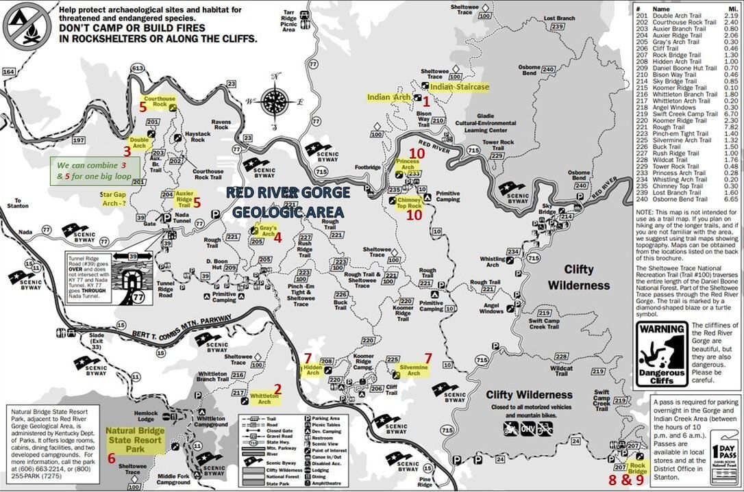
Click on the image for a larger version.
Based on the website, the book and the map, I figured any of the “top ten” hikes would be great options for this group. I was particularly intrigued with the first hike on the list, Indian Staircase and Indian Arch, However, while the website description of the hike started with it being a “favorite trail” the next sentence was “This hike can be VERY dangerous and possibly deadly.” That’s not exactly what I’m looking for and I’m pretty sure that Lynn, Donna and Rhonda would prefer something less death-defying. If I’m being honest, I bet Chris, Oscar and I would have hiked it.
We’ll figure out the specific trails to hike once we are in Kentucky, based on the conditions and how we are all feeling each day. That’s as much of a daily hiking plan as we really need.
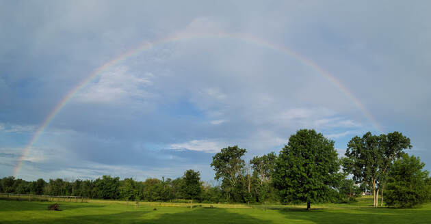
Day 1 - Wednesday, June 9 - Travel Day. Today started like any other day with the normal routine including going out to the barn to feed the cats and give the old man his meds. Interesting weather as the morning sun was shining brightly and there were large patches of blue shy showing through the clouds, but right over the ranch it was raining. OK, the conditions are ideal, so where’s the rainbow. We do tend to get a lot of rainbows here, but usually later in the day so looking east. However, at this time of the morning, the sun is still off in that direction so the show should be to the west….and there it is! And the complete arch as well. As I’m not sure which is the “end” of the rainbow, and I’m already tight on time, I reckon I won’t look for the pot of gold. Hopefully this is a good omen for the trip.
We’ll figure out the specific trails to hike once we are in Kentucky, based on the conditions and how we are all feeling each day. That’s as much of a daily hiking plan as we really need.
Day 1 - Wednesday, June 9 - Travel Day. Today started like any other day with the normal routine including going out to the barn to feed the cats and give the old man his meds. Interesting weather as the morning sun was shining brightly and there were large patches of blue shy showing through the clouds, but right over the ranch it was raining. OK, the conditions are ideal, so where’s the rainbow. We do tend to get a lot of rainbows here, but usually later in the day so looking east. However, at this time of the morning, the sun is still off in that direction so the show should be to the west….and there it is! And the complete arch as well. As I’m not sure which is the “end” of the rainbow, and I’m already tight on time, I reckon I won’t look for the pot of gold. Hopefully this is a good omen for the trip.
Once the cats were taken care of, it was time to finish getting ready for the trip. With all we have left to do, including a trip to the grocery store, we’re not going to make the hoped for 10:00 AM departure. That’s OK as we really don’t have anything going on this evening other than visiting and dinner at the cabin. By the time we had the errands and packing done, the time was 11:20 when we were on the road.
I guess we must be a little out of practice for traveling, and probably were a little lax in terms of checking off the packing items, since this was a road trip. I mean, our attitude was that since we are driving we take way more stuff than we need as the only limit is the cargo space in the Edge. It’s not like we have to really conserve space and weight like when flying somewhere. All that said, we were not to the end of our road before we realized we had forgotten to pack a few items. First thing we remembered were the Yetis and beer glasses (we remembered the beer and wine, so at least the important stuff is with us). OK, it is less than a mile back to the house, but there is no turning back. We can live without that stuff for a weekend. A few more miles down the road and I was starting to get hungry. An apple would have been perfect, but I forgot those as well. That must have triggered Lynn’s memory; the butter for the bagels is still in the fridge (I have my peanut butter, so my bagels will be covered). I guess the moral of the story is that we need to have a better checklist for road trips to match the checklist we use for our big trips out west.
We had the route plugged into Baby and the weather was cooperating. Maybe that rainbow is helping. But the reach of the rainbow must have been limited. While we were dry for the drive out route 42 into Lodi, it was not long after we were on I-71 heading south that the skies grew dark and finally opened up. It rained on us pretty much the entire time we were on the Interstate. Deluged at times. I mean like pouring water out of a bucket such that the windshield wipers were next to useless. The good news was that traffic was not that heavy and most everyone was taking it easy with the less than ideal driving conditions.
While I was focused on driving and the horrid conditions, Lynn was still able to look around and enjoy the scenery, such as it was. She did get a couple interest bird sightings along the Interstate. She was not able to positively identify either, but they were some sort of waterfowl, most likely ducks of some sort. I reckon we’ll just list then as gone birds, just bigger then the little brown birds that usually fall into the category.
Baby and Google Maps kept us on course. The amount of available information on the mapping app is amazing. We know where the speed traps were (not that we were speeding in this rain!), the construction sites were marked and we were given options to reroute around accidents. As it happens, there was a major crash of some sort on I-71 just east of Cincinnati that was causing a 2-hour delay. The alternate route was queued up, but we were hoping that this slow down would be cleared by the time we got into the area. Lynn kept an eye on the situation. A couple other incidents popped up we as drove diagonally across Ohio, but none caused us any grief, although we were routed around one at some point between Columbus and Cincy. As for the big delay reported outside of Cincinnati, we never found out what the cause was but as we hoped it had cleared by the time we rolled through. Hopefully it was not too serious and everyone involved was OK.
Driving through Cincinnati was sort of odd. Due to construction on the Interstate through the city and work on at least one bridge, we were routed off the highway and through the city streets through downtown. There was a bit of a back-up when we were getting back on I-71, just before crossing the Ohio River, but that was just a few minutes, so not bad. The bridge we crossed was getting some maintenance including a fresh coat of paint. It was completely covered, encased in a cocoon of sorts, I guess to contain the spray of the paint. More like driving through a tunnel than a bridge. This caused no slow down for the south bound traffic, but there was a long line of cars filling the northbound lanes and they were basically stopped. That’s not good. Not sure if this was due to the bridge painting, other construction or some weather-induced debacle, but those folks were not going anywhere fast at present.
The rain subsided once we got south of Cincy and had taken the split onto I-75 toward Lexington. Glad that it did as I was getting a bit worn out. Driving in those conditions is never easy, and I’m also out of practice as I have not been driving near as much and certainly not for long distances over the course of the pandemic. While it is still overcast, the skies are brighter and conditions are much better. Shoot, it is time to don the Maui Jim’s!
As we approached Lexington we started seeing several very expansive horse farms. Well, this is where a lot of Thoroughbreds come from. We had seen The Kentucky Horse Park on the map and thought that might make a nice stop on the drive home, but we did not see any signs pointing the way as we drove through the area. Maybe it is closed due to COVID?
We cruised east of Lexington on I-64 to just past Winchester where we exited onto the Bert T. Combs Mountain Parkway. Pretty drive through the hills. This took us right into the Red River Gorge area. We left the parkway and took the Natural Bridge Road past the state park and the few restaurants in the area. The Mexican joint looked to be packed. Well, it is almost 5:30 so the dinner hour is upon us. There’s the pizza place, which also seemed to be on the busy side. I guess it was a good idea that we decided to eat-in tonight. We also spotted teh parking for the underground cave rafting and kayak tours. I guess that could be an option for this week if we get rained off the trails. Of course, maybe being in a flooded cave during a rainstorm is not the best of ideas. We finally wiggled around the narrow country roads that were lined by rentals and vacation cabins to our digs for the next few days, the Bear Grass Lodge. Rhonda had texted us to look for the red pick-up in the driveway, which was a helpful bit of information. We rolled right to the cabin at 5:30. Yep, if we had started at 10:00 AM, we probably would have arrived right at 4:00 PM, as originally planned. But then the timing of the drive could have been thrown off by the construction, weather and accidents. No matter, we’re here now, so all is well.
After a round of hugs and handshakes (hey, we’re all vaccinated, so willing to take the risk) we got settled in. We got the downstairs bedroom which also included a nice sized living room and a screened-in porch, so a nice big area. That suited us just fine. The gang all pitched in and carried our gear inside, just as the rain started. Talk about good timing.
Bear Grass Lodge as this cabin is called is very nice, but a bit on the small side, at least for six adults. And it was a little light on chairs, but we brought camp chairs so that worked out. The kitchen was the tightest space, not nearly big enough for the cooks, but they made due.
By 6:00 we were arrayed around the kitchen table where we spent the rest of the evening. The theme of the evening was old friends, new beers and a great dinner. The guys immediately started sampling the beers that Oscar and I had brought along to share. Oscar had gone the extra mile and checked my wish list on untapped and was able to find a few of those to share. Thanks, Oscar! He had found several of the low- and no-alcohol IPAs that I was wanting to try. Sadly, these were generally disappointing, so my search for a truly flavorful yet sessionable IPA continues. Oscar did warn me to set my expectations low for these and as usual he was correct. Here are my comments from Untappd:
- Free Wave Hazy IPA, Athletic Brewing Company (0.4% ABV, 55 IBU): Like having sex in a canoe…. I could only muster a 2.25 rating on the 5.0 Untappd scale, and that was being generous.
- Light Speed, Brewdog (4.0% ABV, so truly a session IPA not an extreme NA beer): Better than I expected. Won’t be a go to, but I will drink it again. Nice aroma and decent flavor. Fruity, very fruity. Mango or papaya, maybe? 4.0.
- Wild Run IPA, Athletic Brewin Company (0.4% ABV, 35 IBU): OK, better than the previous NA from Athletic, but still lacking where it matters. I will say that the aroma is pleasant but the flavor is lacking. 2.75.
- Non-Alcoholic Juicy IPA, Untitled Art (0.5% ABV): Best of the NA options for the day. I think I will stick to the high-octane beers for now. 3.5.
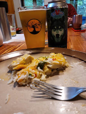
The good news was he also had a Double-dry-hopped Dirt Wolf DIPA from Victory (9.6% ABV). Dirt Wolf is an old favorite and I’ve been looking for the DDH version. This was a very good DIPA. Nice aroma, pretty smooth…just a good beer (I gave it a 4.25 rating on Untapped). That certainly makes up for the low-alcohol pretenders we just choked down.
Rhonda whipped up a chicken and rice dish that had a bit of spice to it thanks to the jalapeno peppers. Not too much, or Lynn would not have been able to eat it, but just enough to add some flavor and just a touch of heat. The Dirt Wolf paired nicely with the heat in this dish.
We talked about travel, of course. Things were a little slow over the course of the past year, but we all had at least one trip to share. I brought along the Alaska photobook, which got passed around this evening. We’ll save Chris’s slideshows for later in the weekend. There were a few idiot tourist tales to share as well. When you visit the big National Parks, there are just too many of these examples. In Yellowstone, there are always tourists getting too close to the wildlife, like the guy standing next to his car in the middle of the road in Lamar Valley as the bison herd ambled passed. Donna regaled us with stories of their recent backpacking excursion in the Grand Canyon this past April. Campers taking dogs into the canyon and many setting off for campsites without permits. So many folks who think the rules do not apply to them.
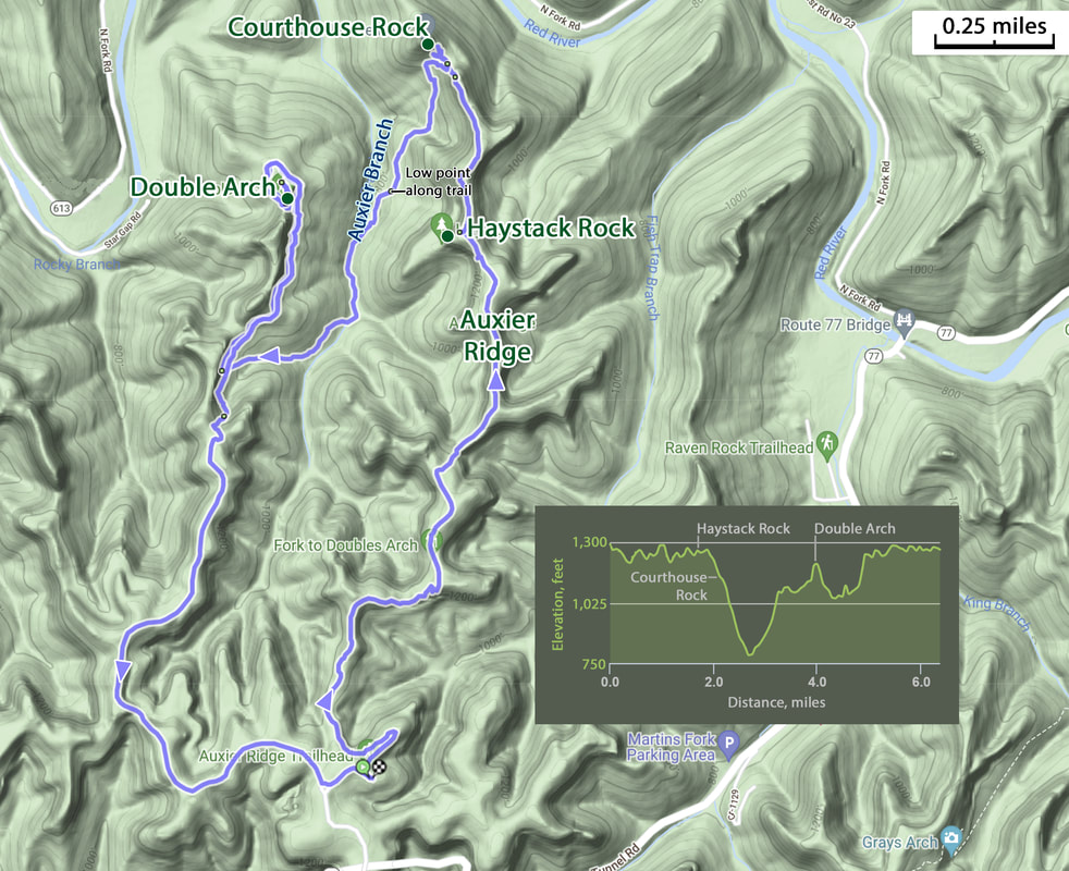
We also developed a plan for tomorrow. I had the map and the hiking book, so the gang left the trail selection to me. The good news is that the forecast indicates that the rain should hold off until mid-afternoon, so we should have time to get in a nice hike. I stuck with the Top Ten List and decided that we should combine numbers 3 and 5 into a nice big loop. This will allow us to see Courthouse Rock and Double Arch. That would be a 6 to 7 mile hike, so a nice stretch of the legs. We’ll see if we can complete that loop before the weather rolls in.
Day 2 - Thursday, June 10 - Courthouse Rock and Double Arch Loop. I was up at about 0600 and went out to our sitting area to check email and surf the net a bit. It did not seem that there was any action upstairs yet. Lynn joined me in the family room area and we got ready for the day while waiting for the rest of the crew to start moving.
I spent some time out on the back porch. The cabin is built overlooking a ravine with a small creek at the bottom. A very green view looking out over the hillside and down into the creek. Lots of birds were singing this morning, but none were visible. I used the BirdNET app on my phone to identify a Carolina Wren, so that’s the first critter added to the list for our time in Kentucky.
Once we heard the activity upstairs, Lynn and I went up for breakfast. Coffee was her first priority. Folks were working around each other in the tiny kitchen. Many cooks making breakfast. Fortunately, Oscar had moved the toaster out of the kitchen and over to the fireplace in the dining area to help reduce the congestion. I toasted my bagel and found a seat out of the way of all the bustle.
The scope of the morning slowly evolved from eating to getting ready for a hike. Folks got their gear in order, filled their water packs, and checked the batteries in their cameras. By 9:00 AM or shortly thereafter, we were loaded up and on the road for the 30-minute-ish drive Auxier Ridge Trailhead. From the first glance at the map, you would think that the quickest route would be by taking the Nada Tunnel Road to Tunnel Ridge Road where the trailhead is located, but that won’t work. Nada Tunnel Road and Tunnel Ridge Road don’t connect, they cross over/under each other via the tunnel so there is no intersection. Of course, Google maps had this all figured out anyway, and directed us along route 15 to the Tunnel Ridge Road. We rode with Oscar and Donna and we only missed one turn. Oscar did a masterful job of getting his big, white Ford F-250 turned around on the narrow road. Chris, who was following, had to do a similar maneuver but had an easier time with his smaller Dodge pickup.
The Tunnel Ridge Road was in good shape. Dirt road, but no issues. I was not sure what we might get here in rural Kentucky. Narrow, yes, but pretty smooth and not that winding, which is a plus for the motion-sickness members of the group. We went to the end of the road to the parking area for the trail. Already pretty full, but there were still a few available spots. Oscar picked one at the far end of the lot while Chris picked one near the entrance. We got our gear in order, Chris and Rhonda made their way down to the rest of us, probably more so because we were parked near the outhouse. While folks were making their final trips, I studied the map a bit then tucked the book in my pocket for future reference. We were all ready to roll just a little before 10:00. I started the Ramblr track at 9:52 AM.
The start of the trail is at about the midpoint of the parking area. We stopped briefly to study the signage there. I pointed out the planned route one last time, just to make sure we were all on the same page. The route is a loo with a spur that goes out and back to Double Arch. This is a complex of trails so we’ll have some options as to how we connect the dots. We’ll start by going out along the Auxier Ridge Trail to Courthouse Rock, then connecting across on the Auxier Branch Trail to the Double Arch Trail, taking the out-and-back to the arch then following the Double Arch Trail back around to the trailhead. That should give us a nice trek for today. OK, that’s the plan, now let’s get going. Get going...move along… I think we were all waiting to see who was going to lead the pack. The trail here is sort of narrow, so single-file. Somehow, I was elected to take point. OK, but I really don’t like going first. I can be a pretty speedy hiker, so I’m always concerned that I’ll set too fast of a pace. Plus I like to stop a lot for photos or to study details along the way. I find it easier to bring up the rear as I can always easily catch up to the slower hikes in front. But today, at least to start the hike, I’m the trailblazer. We are off.
It did not take us long to get in the usual hiking order, with the girls in front followed by the guys, as we tend to stop, study and take more photos. But we did leapfrog each other all along our route, but generally kept good tabs on where everyone was.
Here are some (OK, a lot) of details from the hike:
Rhonda whipped up a chicken and rice dish that had a bit of spice to it thanks to the jalapeno peppers. Not too much, or Lynn would not have been able to eat it, but just enough to add some flavor and just a touch of heat. The Dirt Wolf paired nicely with the heat in this dish.
We talked about travel, of course. Things were a little slow over the course of the past year, but we all had at least one trip to share. I brought along the Alaska photobook, which got passed around this evening. We’ll save Chris’s slideshows for later in the weekend. There were a few idiot tourist tales to share as well. When you visit the big National Parks, there are just too many of these examples. In Yellowstone, there are always tourists getting too close to the wildlife, like the guy standing next to his car in the middle of the road in Lamar Valley as the bison herd ambled passed. Donna regaled us with stories of their recent backpacking excursion in the Grand Canyon this past April. Campers taking dogs into the canyon and many setting off for campsites without permits. So many folks who think the rules do not apply to them.
We also developed a plan for tomorrow. I had the map and the hiking book, so the gang left the trail selection to me. The good news is that the forecast indicates that the rain should hold off until mid-afternoon, so we should have time to get in a nice hike. I stuck with the Top Ten List and decided that we should combine numbers 3 and 5 into a nice big loop. This will allow us to see Courthouse Rock and Double Arch. That would be a 6 to 7 mile hike, so a nice stretch of the legs. We’ll see if we can complete that loop before the weather rolls in.
Day 2 - Thursday, June 10 - Courthouse Rock and Double Arch Loop. I was up at about 0600 and went out to our sitting area to check email and surf the net a bit. It did not seem that there was any action upstairs yet. Lynn joined me in the family room area and we got ready for the day while waiting for the rest of the crew to start moving.
I spent some time out on the back porch. The cabin is built overlooking a ravine with a small creek at the bottom. A very green view looking out over the hillside and down into the creek. Lots of birds were singing this morning, but none were visible. I used the BirdNET app on my phone to identify a Carolina Wren, so that’s the first critter added to the list for our time in Kentucky.
Once we heard the activity upstairs, Lynn and I went up for breakfast. Coffee was her first priority. Folks were working around each other in the tiny kitchen. Many cooks making breakfast. Fortunately, Oscar had moved the toaster out of the kitchen and over to the fireplace in the dining area to help reduce the congestion. I toasted my bagel and found a seat out of the way of all the bustle.
The scope of the morning slowly evolved from eating to getting ready for a hike. Folks got their gear in order, filled their water packs, and checked the batteries in their cameras. By 9:00 AM or shortly thereafter, we were loaded up and on the road for the 30-minute-ish drive Auxier Ridge Trailhead. From the first glance at the map, you would think that the quickest route would be by taking the Nada Tunnel Road to Tunnel Ridge Road where the trailhead is located, but that won’t work. Nada Tunnel Road and Tunnel Ridge Road don’t connect, they cross over/under each other via the tunnel so there is no intersection. Of course, Google maps had this all figured out anyway, and directed us along route 15 to the Tunnel Ridge Road. We rode with Oscar and Donna and we only missed one turn. Oscar did a masterful job of getting his big, white Ford F-250 turned around on the narrow road. Chris, who was following, had to do a similar maneuver but had an easier time with his smaller Dodge pickup.
The Tunnel Ridge Road was in good shape. Dirt road, but no issues. I was not sure what we might get here in rural Kentucky. Narrow, yes, but pretty smooth and not that winding, which is a plus for the motion-sickness members of the group. We went to the end of the road to the parking area for the trail. Already pretty full, but there were still a few available spots. Oscar picked one at the far end of the lot while Chris picked one near the entrance. We got our gear in order, Chris and Rhonda made their way down to the rest of us, probably more so because we were parked near the outhouse. While folks were making their final trips, I studied the map a bit then tucked the book in my pocket for future reference. We were all ready to roll just a little before 10:00. I started the Ramblr track at 9:52 AM.
The start of the trail is at about the midpoint of the parking area. We stopped briefly to study the signage there. I pointed out the planned route one last time, just to make sure we were all on the same page. The route is a loo with a spur that goes out and back to Double Arch. This is a complex of trails so we’ll have some options as to how we connect the dots. We’ll start by going out along the Auxier Ridge Trail to Courthouse Rock, then connecting across on the Auxier Branch Trail to the Double Arch Trail, taking the out-and-back to the arch then following the Double Arch Trail back around to the trailhead. That should give us a nice trek for today. OK, that’s the plan, now let’s get going. Get going...move along… I think we were all waiting to see who was going to lead the pack. The trail here is sort of narrow, so single-file. Somehow, I was elected to take point. OK, but I really don’t like going first. I can be a pretty speedy hiker, so I’m always concerned that I’ll set too fast of a pace. Plus I like to stop a lot for photos or to study details along the way. I find it easier to bring up the rear as I can always easily catch up to the slower hikes in front. But today, at least to start the hike, I’m the trailblazer. We are off.
It did not take us long to get in the usual hiking order, with the girls in front followed by the guys, as we tend to stop, study and take more photos. But we did leapfrog each other all along our route, but generally kept good tabs on where everyone was.
Here are some (OK, a lot) of details from the hike:
- The first section of the trail, from the trailhead to Courthouse Rock, was more or less level. No significant elevation changes, just rolling along through the woods with an occasional glimpse of the bigger vistas. As we continued north, those bigger vistas became more frequent as we worked along Auxier Ridge.
- Early in the hike the trail traversed a section of exposed sandstone. This rock could have come straight from Utah given the color, texture and contours. Just a small exposed section, but very pretty. And somehow I managed to not get a photo.
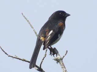 Eastern Towhee
- We did not see any megafauna during the hike, but there were lots of little guys all along the trail. The first sightings were some song birds as we were approaching Auxier Ridge. Actually, some of these were “soundings” rather than sightings as there were plenty of birds singing in the foliage but the leaves were so dense that seeing the birds, much less getting photo, was a longshot. But I did use BirdNET to identify one of the calls, a Prairie Warbler, and I caught a fleeting glance as it dashed across an opening in the woods. That’s a new one for the overall list.
- There were only a couple birds that I got a good look at. One was a Turkey Vulture circling overhead as we crossed the ridge. Maybe he thought we were not going to survive the hike and was sizing us up for dinner. Before the vulture, there was one songbird that I was able to get a couple photos of as it sat in a dead tree on the edge of the clearing. An Eastern Towhee. It was also serenading us as we walked past.
- Once out in the open along Auxier Ridge we had an excellent vista, particularly looking off to the east. We found an open area of sandstone that afforded us a grand view over the ridges and valleys extending out for miles. We also spotted Double Arch. By zooming in with the camera we could see folks standing in the larger opening of the arch. OK, we’ll be over there later. Another vantage point provided a view looking to the west. Not as “big” of a vista but we think we were looking into the Red River at one point.
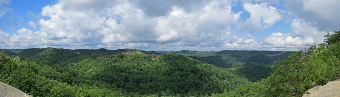
View looking east from Auxier Ridge toward Double Arch (in the first ridge line at the center of the image).
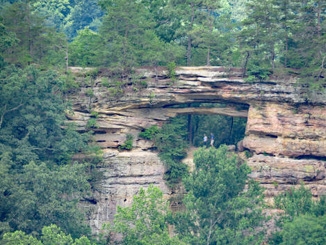 Long-distance view of Double Arch from Auxier Ridge.
- Perfect weather for a hike at this point. Sure a little muggy and warm, probably low 80s, but blue sky behind all the big, white, fluffy clouds. Since much of the trail has been shaded, the conditions have been overall very comfortable
- Remember how I mentioned that we like to keep track of each other during our hikes, just to make sure everyone is OK. Oscar and I seem to be the herders in this regard. So it was sort of ironic that we lost track of our flock at one point after we stayed a little longer at one of the viewpoints. I was trying to get a photo of a Black Swallowtail that was flitting about just below the edge of the ridge, but it was not cooperating. By the time we were back on the trail, the herd was out of sight. No worries, they could not have gone far and would be just up the trail. The problem was that we came to a fork in the trail. Hopefully they were paying attention when we went over the route and stayed to the right, as that is what Oscar and I did. We picked up the pace a bit and caught up with the gang just a short distance up the trail. I guess if we had not have caught them we could have tried calling them as there was probably at least a bar or two of cell service out here.
- Lynn and I ended up in front of the pack for a while as we were approaching Haystack Rock and we spotted a lizard in the trail ahead of us. We were able to get decent long-range photo of the little guy, figuring it would scurry off if we got too close (which it did once the rest of the group approached). Looked like a fence lizard that we see so often in the southwest. Based on the photo and a little search on the web, I later confirmed that it was an Eastern Fence Lizard (Seek said it was a Northern Fence Lizard, but the websites on Kentucky wildlife listed the Eastern Fence Lizard as living in the state; seems the names may be used interchangeably for the same species of fence lizard).
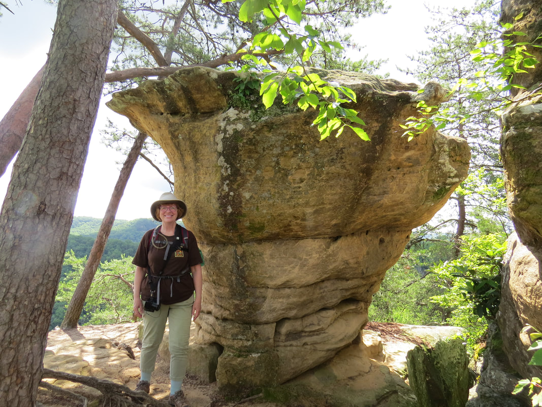
- The next point-of-interest along our route was Haystack Rock. There were two other hikers there when we arrived, the first other folks we had seen on the trail. Looked like they were just finishing a snack and were heading on in the direction we were traveling. We looked around for a few minutes. Sort of a neat formations with was interesting features. There were crevices along the ledge of the rock that reminded me of the deep cracks along the trail leading out to Taft Point in Yosemite. Also a balance rock or maybe more appropriately a toadstool formation (could we call it a hoodoo?). Interesting example of the forces of nature on the sandstone. The vantage point from Haystack gave us a nice view of our next stop, Courthouse Rock, which was not that far away as the crow flies. But we aren’t crows.
- After Haystack Rock, the trail went down a long set of wooden stairs. These were not standard state park wooden stairs. While the standard steps and stairs found on trails are usual sturdy and secure, they tend to be simple and to the point means to get hikers from point A to point B. These stairs were certainly sturdy and definitely got us to where we needed to go, but they did so in a more aesthetically pleasing fashion. The folks who build this stairs were certainly craftspersons, given the arc of the structure and the curved handrail. Well done.
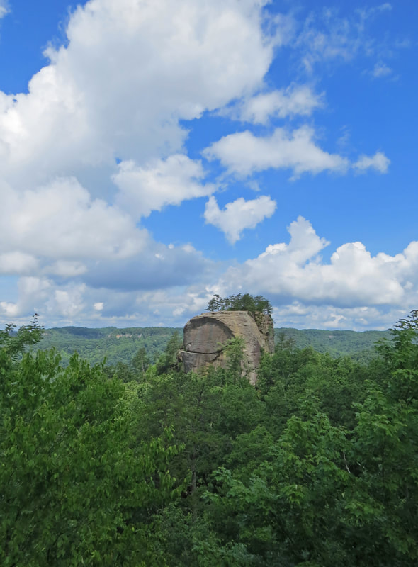
Courthouse Rock viewed from Haystack Rock.
|
Lynn at a mushroom formation at Haystack Rock.
|

Very handy carpentry.
|
- Next stop, Courthouse Rock. That’s a big rock. The signage along the trail as we approached the sandstone behemoth warned against attempting to climb the rock. Death was a possible outcome of disobeying these warnings, most likely due to deceleration trauma and or sandstone poisoning. In any event, climbing the rock was not on my list of things to do today.
- We did explore the area from the safety of the trail. The girls were happy to marvel at Courthouse Rock from the main trail, but us guys needed a closer look. There were some interesting details. Like the Five-lined Skink we spotted sunning itself on a little rock next to the big rock. We walked around the base of the rock as far as we could, but a safe route did not appear to circumnavigate Courthouse Rock. No worries. We went as far as we could in one direction then backtracked and went around the other way for a short distance. Very cool hanging gardens growing from the seeps in the sandstone. There were a couple trees seeming to grow out of the rock as well. As Dr. Malcolm said, “life finds a way.”
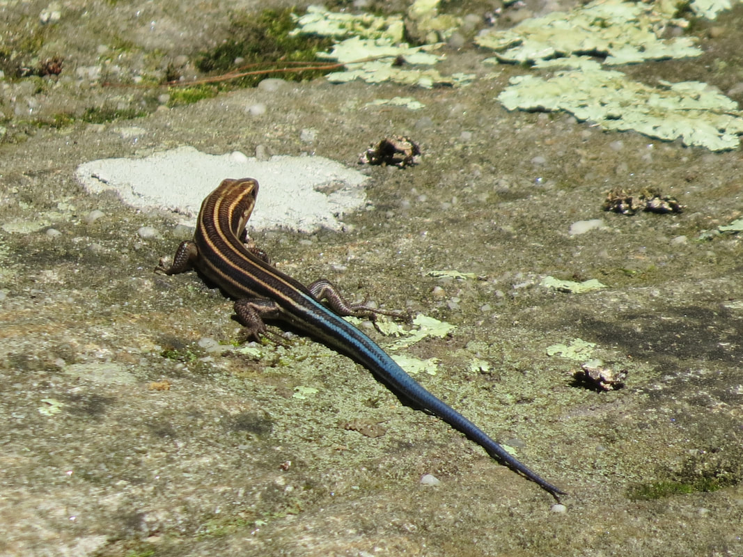
Five-lined Skink
|
Hanging Garden
|
And hanging on!
|
- As we were leaving the area, someone pointed out a little secluded area above the trail. Pretty little spot, lush and green. Would make a nice place for a picnic or a nap, or both. There was a little connector trail to this area, so I walked to the edge for a better look. Yes, shady and restful, it seems. Maybe sort of the lure of a trap though, since as I turned to leave this nice little spot, the edge of the trail gave way from under my left foot and down to on my knees I went. No harm done but just a reminder to watch your step particularly near the edge of a trail.
- From Courthouse Rock we took the Auxier Branch Trail down into the valley…gorge, ravine…I’m not sure of the correct term so I’ll just go with valley. The first few steps took some negotiation. Sort of odd considering the lovely staircase we came down to get to Courthouse Rock from Haystack. Maybe we missed the easy route, but with six pairs of eyes you would have thought that we would have seen it. However, we’re all used to these little obstacles and willing to give a hand or a boost or do a little scrambling when the situation calls for it. We were soon on our way down into the little valley.
- So far we had not seen a lot of traffic along the trail. Maybe the threat of rain was keeping folks away. There were a couple people back at Haystack Rock but that was all we saw along Auxier Ridge. We did pass a couple groups coming up the trail as we were heading down toward the creek. Maybe a dozen total. I think they were actually all one big group that had gotten strung out as then went along. Probably two or three families; kids, teens and parents, out for a day in the woods.
- This part of the hike was a completely different experience. From the trailhead to Courthouse Rock we were hiking along the ridge line, more or less, with some stretches in the woods but plenty of big vista views as well. Now we are heading down into the valley that contains Auxier Branch. While the valley is pretty wide, the feel of the trail was different. A bit darker due to the heavier foliage and no more big vistas. The views were of the forest. Still lovely and oh, so green.
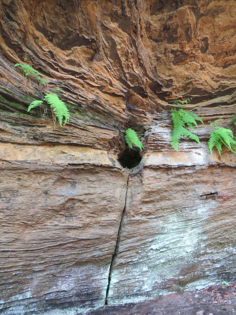
- Without the panoramic views to capture our attention we turned to details along the trail, and there were plenty of details to see: the plants, odd rocks, some interesting fungi and a few insectivorous critters. We had a little fun using Seek to try and identify the various organisms. Figured out a few as we hiked down the hill toward the creek.


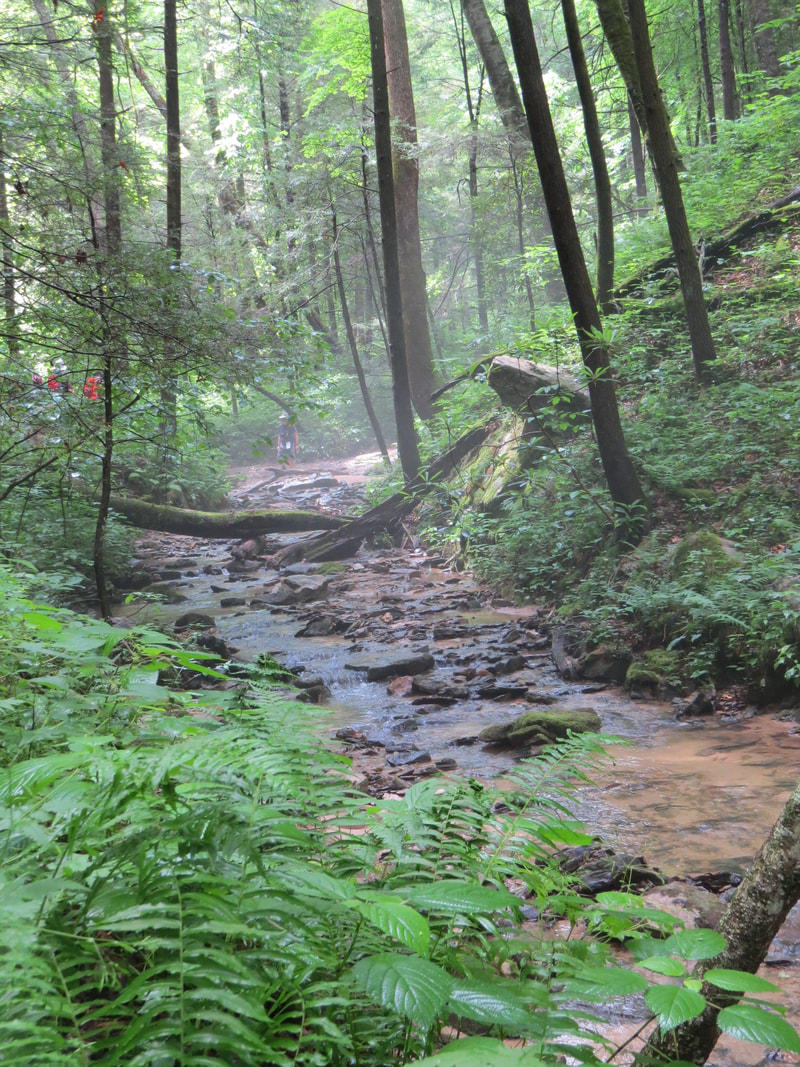
- The trail leveled out for a while when we reached the creek. I guess really we started a slight ascent once we reached the water, since the creek was flowing toward us. Nice area here in the bottom of the little valley, still very lush and green. Actually a little foggy right along the creek, which provided a touch of eerie ambiance to the area. More little details in terms of the ferns, mosses and fungi here as we walked next to the creek. We paused a time or two to enjoy the scene and rock-hopped a bit to get the perspective from the creek itself.
- Eventually the trail crossed the creek and we did as well. Very shallow here so no worries with getting wet boots. Once across Auxier Branch, there was a much more noticeable upward tilt to the trail and we began a slow ascent out of the valley.
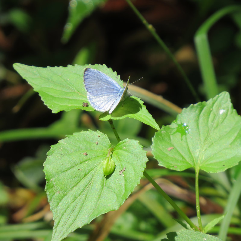
- I was trailing the herd for most of the hike through the valley and was still bring up the rear when we crossed the little creek. I paused here as there were some little blue and white butterflies flitting about the area and I wanted to see if I could get one of them to pose for a portrait. Oddly enough, one did. It landed right on my boot! The bad news was that was a next to impossible location to get a decent image. And I was concerned that if I moved my foot to get a better angle and more favorable light that the little goober would just fly away. Well, I tried slowly moving my foot but sure enough the butterfly flew away. Fortunately, it landed on a nearby shrub at just the right angle and in a nicely lit spot, so I got a nice image of a Holly Blue.
|
|
- After chasing butterflies, I figured I had best catch up with the gang. They were not too far ahead. We stopped at the intersection with the trail out to Double Arch. It seems that we were in the midst of a “Double Arch or not Double Arch, that is the question” type discussion. The warm temperature, high humidity, and the steep uphill slog since crossing the creek were taking there toll on the troop, but after a bit of a breather all were ready to tackle the trail to Double Arch. Onward!
- Lynn and I ended up in front of the pack for the hike out to Double Arch. This was another uphill climb up to the ridge line that holds the arch but not overly steep. I was following Lynn and noticed that she had a hitch hiker riding on her hat, an emerald green beetle. Pretty critter. It rode along longest time but when we finally stopped so that I could take a photo, it quickly disembarked from her chapeau. Oh well. But I did get a good look at it, so maybe I can do a little searching on the internet tonight and get an ID.
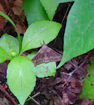
- A short while later I spotted a moth of some sort. Moths are usually more conducive to having their photo taken. I think they will sit still to avoid detection from predators, but that’s just my guess. The trick is to see them in the first place as they will hide in the foliage or under leaves and they typically blend into their surroundings. Seek later decided this was a Discolored Renia Moth.
- As we got closer to the arch, there was one last steep section to tackle via a long, wooden staircase that ran straight up the slope. Nothing fancy like the stairs between Haystack Rock and Courthouse Rock. And these were in need of some maintenance, with a few of the treads being loose and a couple rotted nearly through. On the return trip I warned a couple hikers who were approaching the stairs to proceed with caution and watch for the loose treads. Once off the stairs, our destination was just a short distance away, but the last bit was still uphill. The last portion of the trail loops around the ridge and the arch for final quarter mile. So, for most of the hike up to the arch we were on the east side of the ridge, but then looped around such that we were on the west side when we reached Double Arch.
- I’m glad that we added the side trip to Double Arch as it was a pretty cool formation. Plus, the views from the arch were fantastic. We were now the little dots of people standing in the opening of the arch, like those I saw when I first spotted the arch from Auxier Ridge. When we arrived there were a couple other hikers there, but they were gearing-up for the return hike, so we soon had the arch to ourselves. We took advantage of the solitude to take in the big views, study the details and explore the area.
- Of course, the first thing we did upon reaching the arch was to marvel at the interesting formation that Mother Nature had created. The formation is called Double Arch as there are two openings stacking one above the other. The larger opening is at trail level and affords a natural picture window looking north and east to Courthouse Rock and Haystack Rock. The smaller opening is wide but not very tall and could be easily missed. In fact, it was hard to get a photo that showed both openings, just tough to get the right angle. It was easier to see both openings from Auxier Ridge.
Lynn standing in the larger opening of Double Arch.
|
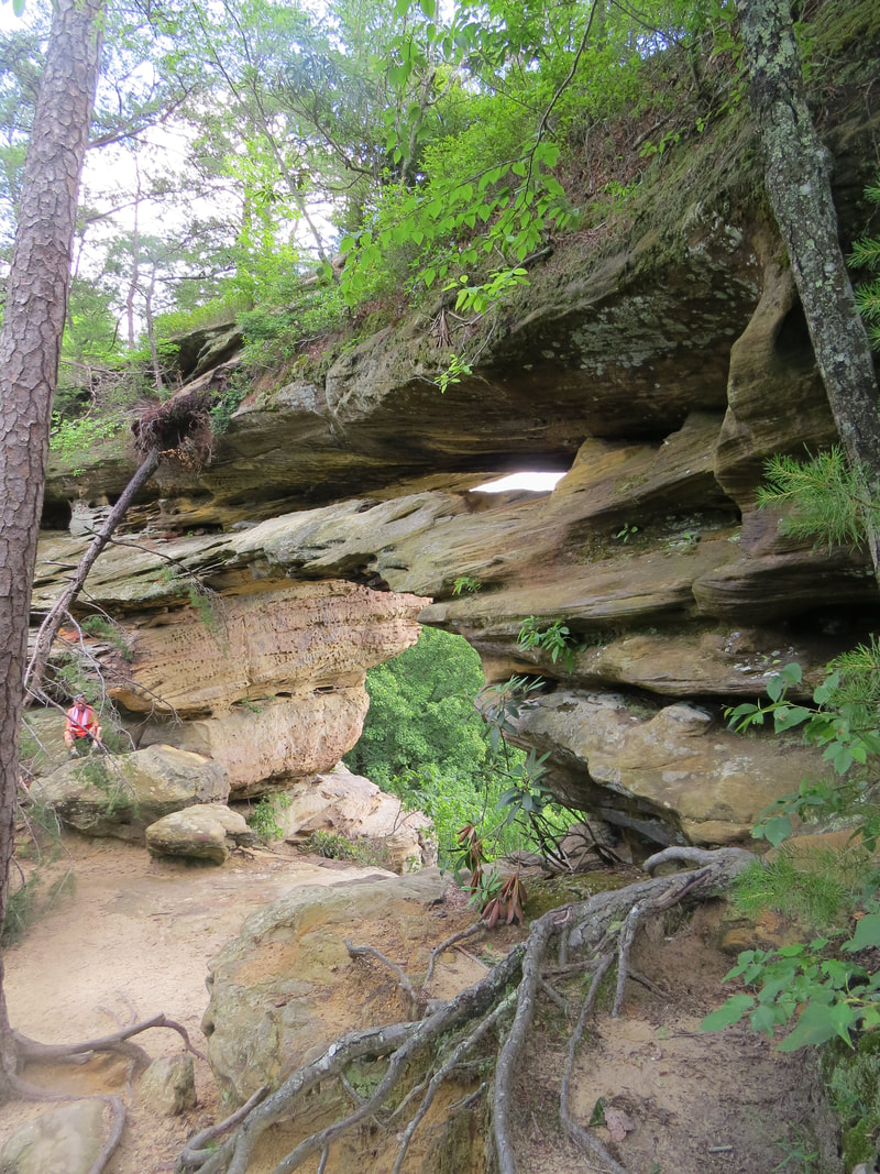
I had to get a higher vantage point to see both openings.
|
- We all walked into and through the main opening to take in the vista. Just a lovely view with the sea of green from the foliage under a bright blue sky that was full of fluffy, white clouds. Truly a beautiful day.
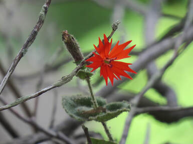
- There was a also a splash of color under the arch with some bright red wildflowers growing along the edge of the arch. Seek said these were Cardinal Catchfly. Quite a brilliant red and the perfect accent to the grey and yellow rock and the verdant backdrop.
- As usual, Chris wondered off from the group, looking for the best photo opportunities, but he quickly reappeared on top of the arch. Turns out there’s a trail that runs along the top of the formation. OK, I’m going to check that out as well. The girls were happy having a snack and just enjoying the view from the main window, so the guys went off in search of whatever we could find.
- The trail worked around to the right of the arch via a set of steps carved into the sandstone. The only trickly part was reaching that first step as it was a few feet above trail level. But there were some convenient roots that provided both steps and handholds, so with a little effort I was able to hoist myself up onto the sandstone and scrambled on up the notched steps then along the trail over the arch and continued to the higher ground further along the ridge, just a bit north of the arch. While the view looking through the main opening of Double Arch was excellent, from up here there was a nearly unobstructed, 360-degree vista. Simply a wonderful view in all directions. The best was still looking northeast toward Haystack Rock and Courthouse Rock, but it was cool just being out on the open ridge with the big view and the wonderful conditions.
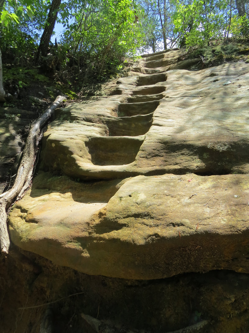
Steps to the top of Double Arch.
|
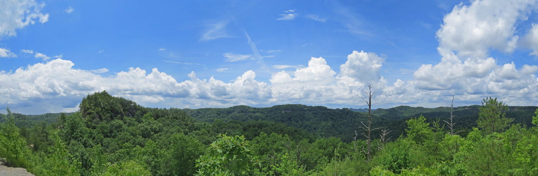
The big view looking toward Auxier Ridge form on top of Double Arch.
|
- Granted, the view was the star of the show from the ridge, but there were plenty of other interesting details, particularly the butterflies. There were many flitting about up here, and there were several varieties. Most, unfortunately, were moving about too much for decent photos. There were a couple Monarchs, a swallowtail, A Red-spotted Admiral and several Northern Cloudywing butterflies.
- Lynn was also adding to the critter count, as she spotted a lizard on the side of a tree near the arch. Very pretty with red spots and blue underside. A Fence Lizard of some sort; Seek suggested an Eastern Fence Lizard.
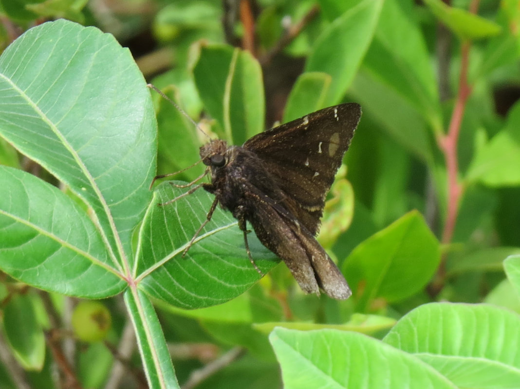
Northern Cloudywing
|
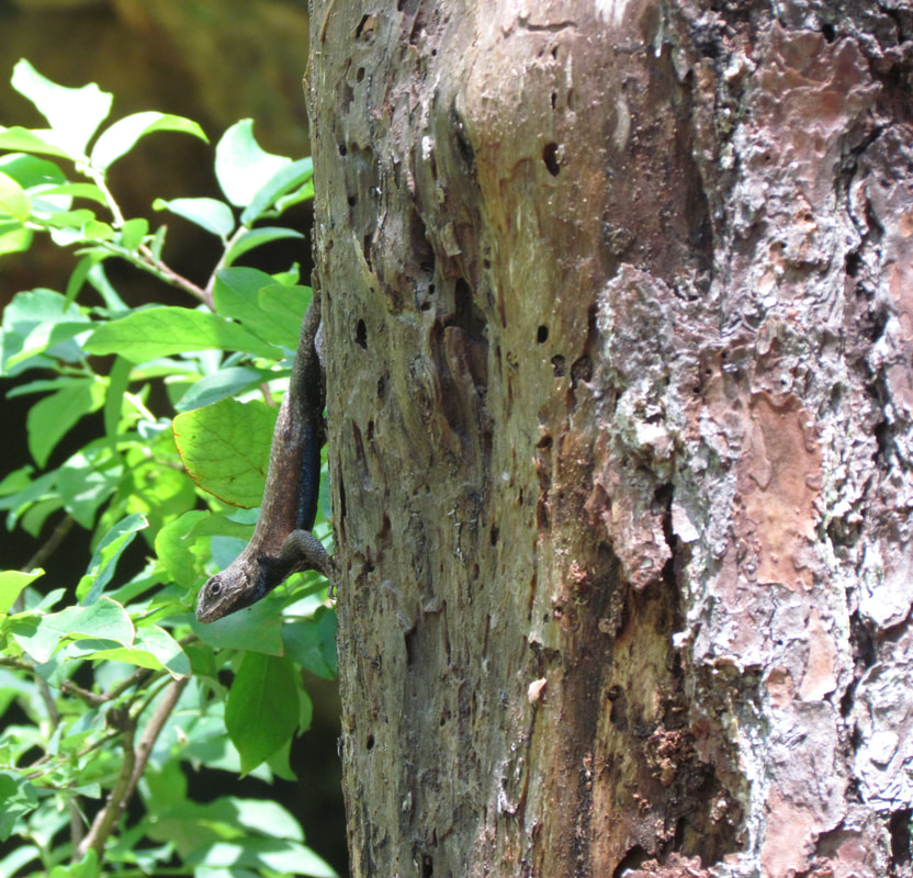
Eastern Fence Lizard
|
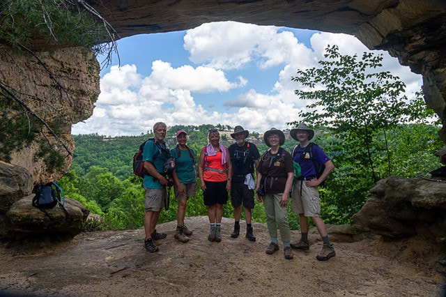 The gang at Double Arch (Oscar, Donna, Rhonda, Chris, Lynn and Allen)
- We enjoyed our time at Double Arch. More folks were arriving as we were getting ready to head out, so we exchanged photographer duties with some other hikers so that we could all get a group photo under the arch. Then we donned our packs and headed back out the trail. The forecast was still calling for rain and we wanted to get back to the trailhead before the weather rolled in. But based on our observations of the current conditions, it seemed that we still had time.
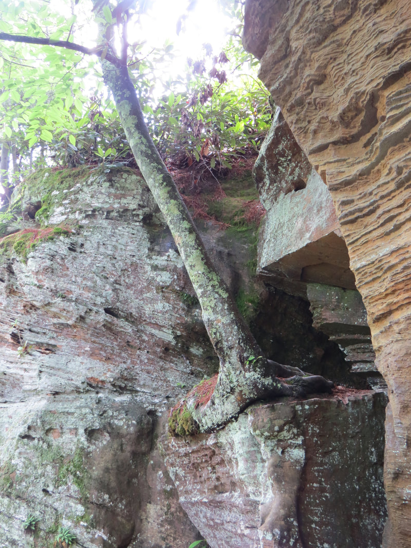
- We backtracked along the Double Arch Trail to the main loop then continued the climb up and out of the valley. Lots of ferns and some interesting rock formations along the trail. We continued to study the rock wall that lined the trail to our right as well as other interesting details. Lynn saw an odd, round object high up in one of the cracks in the rock. Looked like a huge hornet nest based on the color and the shape. We speculated about that for a minute or two, then I just zoomed in with the camera for a closer look. Nope, just a round rock that looks like a hornet nest.
- Chris spotted some old posts along the trail going up the hill. Not really right for a structure. We surveyed the arrangement of the posts a bit and determined that was an old fence line marking the route of a trail, just along a slightly different track that the current trail.
- It was just about this point that we noticed the first signs of rain. Just a few drops at first. We were not sure if it was really raining or just water dripping from the foliage over the trail. But the drops became more persistent and soon was a steady rain. The weather moved in fast considering how pleasant the conditions were back at Double Arch. We found a relatively sheltered spot under the trees to get into our rain gear and put the cameras and phones away. The deluge was on. From that point, we just put our heads down and plowed on through the rain.
- We were soon out of the little valley and on an old dirt road for the last part of the hike. Easy hiking along the old road, but the overhanging trees provided no relief from the pouring rain. We still had well over a mile to get back to the trail head. We were already soaked so we just made the best of it, splashing our way back to the end of the trail. We passed a and group of hikers, perhaps backpackers. Group of 20-somethings. They were as soaked as us, but still had smiles on their faces, just like us. We all waved as we walked by.
- We were finally back at the trailhead right about 3:00, soaked to the bones. The rain let as we were approaching the end of the hike, which give us a nice reprieve and made it easier to get our of our packs and loaded back in the trucks. Hey, even with the rain it was a great hike. Lovely scenery every step of the way. The guys all checked their GPS units. None of our distances matched. I tracked the hike at 7.0 miles, Oscar had 7.8 and Chris was somewhere in between. Whatever the distance, they were quality miles, but after 5 hours of hiking and a thorough soaking, we’re all ready to get back to the cabin, dry off and have a drink.
Here's the link to the photos from the hike.
We made a quick stop at the convenience store on the way back to the cabin. We needed ice. That was one of the minor inconveniences of the cabin, not only was the kitchen on the small side, but it did not have a full-sized refrigerator, so we needed to use the coolers for the beer and even some of the foodstuff. Therefore, ice was a necessity. But that also gave me an opportunity to check out the local beer offerings. Not really anything of note, at least nothing that caught my eye and had a reasonable rating on Untappd. I guess that’s OK as we are well stocked at the cabin.
Once back at the cabin, we were hustling to get our gear unloaded and inside before he rain started again. After taking the first load in through the front door, I decided to try a shortcut and go through the back porch, which had convenient access to the driveway. Unfortunately, that the sloped ramp to the back porch and the wet wood combined to make a classic slip hazard and I busted by butt as I was carrying in the ice. No harm, foul, but lessoned learned. Turns out that Chris had suffered a simple fate yesterday. OK, note to self, stay off that ramp when it is wet.
We all set about getting our gear, clothes and shoes to drying. Hanging clothes out on the porch ain’t going to work due to the high humidity. Chris tired putting his boots in the clothes dryer. Uh, no, that’s not going to work. But a blow dryer, now that should work for drying waterlogged boots. I had the trail book in the big pocket of my hiking shorts for easy access on the trail, and it pretty wet as well. Not soaked through, cover-to-cover, but definitely very wet. I laid it out on the fireplace in the basement and hoped for the best.
After everyone had their stuff set up to dry, we all converged on the dining area. Just barely enough room for us all around the table, but we’re all friends here so togetherness is a good thing.
The guys set-up their laptops and started working on photos. I simply reviewed mine on the camera, confirmed the sightings we made on the trail with Seek (well, confirmed may be a little strong; Seek is useful but not always accurate, I’ve found). I also did a little searching on the web to see if I could identify Lynn’s hitchhiking beetle from the hike up to Double Arch. My best guess is a Six-spot Tiger Beetle, but who knows.
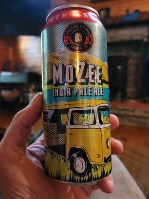
We also started sampling some beers, picking up where we left off last night. Oscar and I each brought a nice variety of brews to share, many pint cans and several crowlers. Both the pint cans and the crowlers work well to split three-ways so that we can all get a decent-sized pour. Here are the comments on the new beers I tried:
|
We also threw in a Dragon Fandango (4.2% ABV, 10 IBU) from Toppling Goliath, one of my favorite sour beers (it gets a 4.5 rating from me on Untappd).
|
Donna was the chef in the kitchen tonight and she whipped up a wonderful meal: crab cakes, mac and cheese, asparagus, and caprese salad (tomato, mozzarella cheese, balsamic dressing). Quite the spread. Of course, not everyone was completely happy. Chris’s initial, tongue-in-cheek comment was “what, no buns?” I see where he was coming from, the crab cakes would have made a nice sandwich, but there was plenty of food on the table so no need for extra bread tonight. As usually with these events, I ate too much, but it is hard to say no to a homecooked meal.
After the dinner table was cleared and the dishes put away, we squeezed into the living area for more talk of travels, discussion of plans for tomorrow and the evening entertainment. For the latter, Chris did his IT magic and got the his laptop and the big TV communicating so that we could review travel slideshows. We started with my Alaska slideshow, then went through photos from Donna and Oscar’s latest Grand Canyon expedition. Talk about two completely different excursions, but both equally fascinating and each highlighted many natural wonders.
As for the Friday plan, tomorrow looks like a certain rain-out based on the forecast and our own analysis of the current and future radar. But then again, we thought today would be as well (yeah, yeah, I know, we did get drenched, but we still got in a very nice hike). We have our list of hiking options but we’ll just have to wait until the morning to see what the weather is like and make a game time decision.
The funny thing is that rain is a common theme with these mini-meet-up events, as we have had at least some precipitation for each gathering. There was the rainy day for our tour of Gettysburg National Battlefield, but nothing that umbrellas could not handle. We were able to stay dry on the trails at Ohiopyle as the rain held off until we had completed our hiking each day, but we had some nice afternoon downpours. But that made for some relaxing porch sitting. Lynn and I missed the first day of the Blackwater Falls meet-up when the rain came through, but the trails were on the muddy side for the rest of the weekend. And of course, we started the Kentucky event with a rainy day. We’ll be sharing a house for the UTAH meet-up in Cortez this fall and that will be a real test. If it rains in Cortez, in the arid, desert southwest, while we are there then we may want to think about selling our services to drought-stricken areas.
This has been a full day with a nice hike, free shower on the trail, excellent dinner and several good beers. But we are running out of steam. Lynn checked-out at 9:00. Good idea. I went for a shower and then called it a night as well.
Day 3 - Friday, June 11 - Looks like a rain-out. I woke up a couple times during the night. It was pouring each time. Apparently, it rained all night. I finally rolled out of bed at 0600 and sat in the downstairs living area. First check was of the weather. Predicted to be a washout today. Well, that’s problematic. Lynn eventually joined me with one of her books, while I continued with email maintenance on the phone. Once we heard action upstairs, we went up to get breakfast.
I had my usual, simple bagel with peanut butter and went out on the back porch to enjoy the peace of the morning while eating. The rain was now steady but gentle and the drops falling through the leaves and splashing off the metal roof was rather relaxing. The birds were adding their songs to nature’s orchestra. While I could hear the birds, there were no sightings to speak of.
After the breakfast dishes had been cleared, we assembled around the table and in the living area to discuss plans for today. Since I had done a fair amount of research on the hiking options and had the trail book, I was somehow elected to figure out the plan for the day. Hey, everyone has their part to play, and I’m happy to be the cruise director. The book had dried out nicely overnight, and while somewhat warped it was completely readable. So, I was looking at the weather forecast and particularly the radar trying to find a break in the rain, as well we the studying the trails to find a shorter but interesting hike, something that might fit within a gap in the weather. Of the Top Ten list of hikes, the best opportunity was probably the trail to Natural Bridge since it is relatively short and not far from the cabin. At about 9:30 I declared that we have a window for a short hike if we go NOW! Rain should break at 10:00 and give us a dry spell of a couple hours before settling in again for the rest of the day. We quickly got our gear together, put on our damp boots and hit the road.
Donna and I both had the directions to the trailhead locked in on our phones and we were there in short order, right at three miles and less than 10 minutes from the cabin to the parking lot. The hiking book showed the hike starting from the lodge, but we were at the Natural Bridge Trailhead parking lot just off the main road (route 11). This will work. Better to get on the trail while it is not raining. Besides, this trail will join with the trail from the lodge for the climb up to the arch. Starting from our location is a little longer, but this already going to be a short hike so the little extra yardage is not a bad thing.
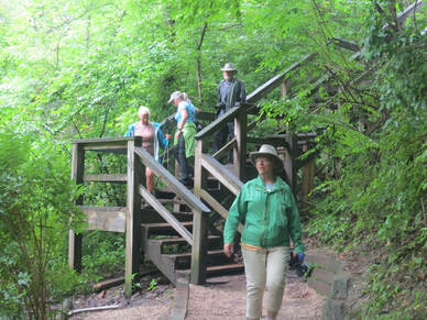
I started my Ramblr track at 10:20 and we walked to the end of the parking lot to get on the trail. We very cautiously made our way down the wooden steps to the river; with all the rain, the wet wood could be quite slippery, as I learned yesterday. This initial part of the trail ran long the river for less than a quarter mile. It had definitely rained here as there were a couple of huge puddles and muddy sections in the trail that we had to negotiate, but previous hikers or park staff had provided some rocks and logs to use as steppingstones across the worse sections.
While the puddle were easy obstacles to navigate, there was on question about this trail that I was unsure of, getting across the Middle Fork of the Red River. Since we were not following the trail described in the hiking book, I had no description of the river crossing. Would we be wading or was there a bridge. After getting down to the river it was obvious this was not going to be little creek crossing like we had yesterday. Nope, this was a real river, and it was running fast with muddy water from the rain. Worse case is that we get to the crossing and have to turn back. The good news was that we could see the bridge across the river after hiking along the trail a bit. OK, that problem is solved, as long as everyone is comfortable crossing on a swinging bridge. Reminded me of the old bridges across the Guyandotte River back home to get to the railroad offices. This one was much shorted and not as high above the river as those, but a swinging bridge can still be disconcerting to some. Fortunately, our little group tramped right across with no issues. We got our first animal sighting of the hike from the bridge, a family of Canada geese, mom, dad and several goslings. The babies were getting big and looked like they were already getting their adult feathers.
While the puddle were easy obstacles to navigate, there was on question about this trail that I was unsure of, getting across the Middle Fork of the Red River. Since we were not following the trail described in the hiking book, I had no description of the river crossing. Would we be wading or was there a bridge. After getting down to the river it was obvious this was not going to be little creek crossing like we had yesterday. Nope, this was a real river, and it was running fast with muddy water from the rain. Worse case is that we get to the crossing and have to turn back. The good news was that we could see the bridge across the river after hiking along the trail a bit. OK, that problem is solved, as long as everyone is comfortable crossing on a swinging bridge. Reminded me of the old bridges across the Guyandotte River back home to get to the railroad offices. This one was much shorted and not as high above the river as those, but a swinging bridge can still be disconcerting to some. Fortunately, our little group tramped right across with no issues. We got our first animal sighting of the hike from the bridge, a family of Canada geese, mom, dad and several goslings. The babies were getting big and looked like they were already getting their adult feathers.
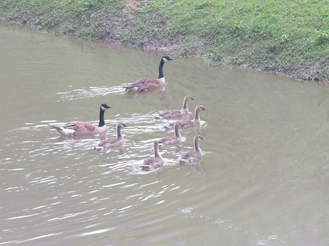
|
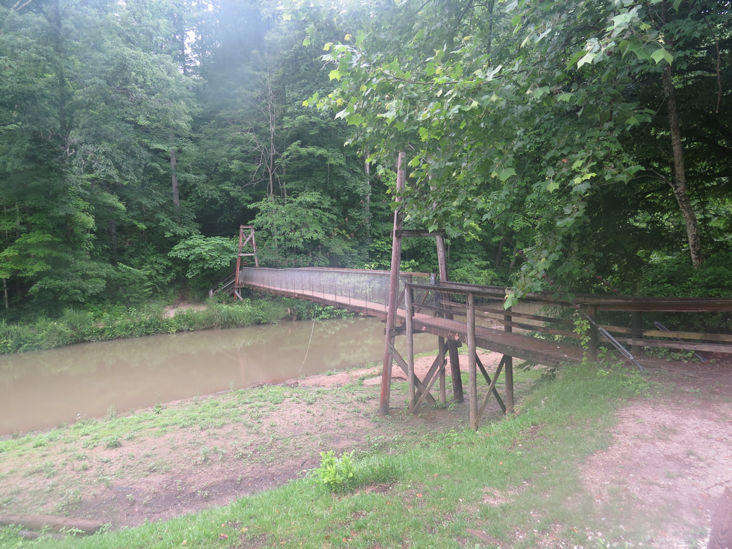
|
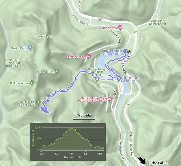
Once across the bridge, we spotted the start of the trail up to the Natural Bridge basically straight out from the end of the bridge. There’s a gift shop off to our right, which we can hit on the return trip if we wish. I was more interested in the little brown birds flitting about in the grass near the start of the trail. Too far for any decent photos. One of the little guys was definitely a Chipping Sparrow. There were a few others bouncing around as well. I managed to get a couple fuzzy images that I used to try and identify the birds using Seek and Merlin, but to no avail. I posted the poor pictures to birdforum.net once I got home. Turns out that one was a juvenile Chipping Sparrow. Makes sense.
Once across the open lawn area we entered the woods and started the uphill section of the trail. Sure, there were some minor ups and downs along the trail, but the general trend was definitely an increase in elevation. Not a long stretch, less than a mile along the uphill section, gaining about 500 feet in elevation from the river to the Natural Bridge.
More folks on the trail compared to yesterday, even with the wet conditions. That will certainly impact the wildlife sightings. But there were a couple other items of interest along the trail, including a few interpretive signs The first provided a little history of the park:
PARK HISTORY - The park was founded in 1895 by the Lexington & Eastern Railroad, a subsidiary of the Kentucky Union Lumber Company. The railroad was built to haul logs out of eastern Kentucky, and the park was built as a sideline to their passenger and freight business. The railroad built this trail, a campground, picnic area and other improvements. For many years, the only way to reach the park was to buy a ticket on the L&E Railroad. In 1926, the railroad donated the park to the state, and Natural Bridge became one of the four original Kentucky State parks. The railroad continued to operate excursion trails from Louisville, Lexington and Hazard until 1942, when the line was dismantled.
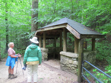
Next up was a small shelter made of stone and timber positioned right along the trail. Looked like just a place to take a rest, but it was large enough to accommodate eight or ten folks (maybe more if folks are squeezing to get in out of the rain). There were four or five of these shelters of varying design scattered along the trail. Those could come in handy if the rain returns before we get off the trail. We speculated that these were probably built by the CCC and a nearby sign confirmed that point:
CIVILIAN CONSERVATION CORPS - This shelter was built in 1934 by the Civilian Conservation Corps. The CCC program was started by President Franklin Roosevelt to employ men from 18 to 25 years old in conservation projects. The work included soil erosion projects, planting trees, building bridges, fighting forest fires and improving state and national parks. CCC enrollees were paid $30 per month, of which $25 was sent home to the family. Room, board, clothing, tools and training were provided by the government. The enlistment period was 6 months, with an option to renew up to 2 years. Hundreds of thousands of young men got their start in the CCC before it was dismantled in 1942. Today, Natural Bridge and other Kentucky State Parks are still benefiting from their work.
CIVILIAN CONSERVATION CORPS - This shelter was built in 1934 by the Civilian Conservation Corps. The CCC program was started by President Franklin Roosevelt to employ men from 18 to 25 years old in conservation projects. The work included soil erosion projects, planting trees, building bridges, fighting forest fires and improving state and national parks. CCC enrollees were paid $30 per month, of which $25 was sent home to the family. Room, board, clothing, tools and training were provided by the government. The enlistment period was 6 months, with an option to renew up to 2 years. Hundreds of thousands of young men got their start in the CCC before it was dismantled in 1942. Today, Natural Bridge and other Kentucky State Parks are still benefiting from their work.
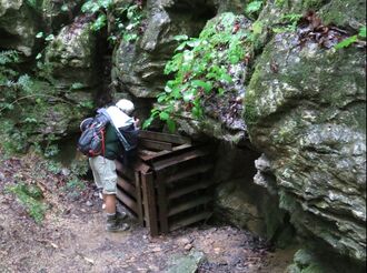
Another point of interest sort near this first CCC shelter was the opening of a cave. It was fenced off, and I don’t mean a simple chain link fence. Nope this was a serious, Medieval armor-pated crate of a fence that completely covered the opening of the cave. No way anyone is going to get through that without a blowtorch or dynamite. You could still see into the cave, so hard to get a good look, but there was certainly an underground opening that dropped vertically for several feet and seemed to open up into a chamber that extended off horizontally. Oscar and I studied it for a few minutes but could not see much. No idea what it was or if it had some purpose or used to be open for exploration. No signage around that I could see, so this one will just remain a mystery.
There was one other sign that I saw talked about the wildlife in the park:
There was one other sign that I saw talked about the wildlife in the park:
|
WHERE IS THE WILDLIFE? Natural Bridge is the home to many different kinds of animals, but visitors sometimes ask why they don’t see more on the trails. If you want to see large numbers of mammals, look in suburban areas. Deer, gray squirrels, raccoons and opossums are just a few of the species that are found in large numbers around city parks and wooded neighborhoods. They do well in disturbed habitats and have adjusted to being around people. In a natural area like this, food is not so concentrated and the animals are more widely dispersed. There are predators here that eat other animals, so they tend to be secretive and travel at night. Finally, wild animals here have not adjusted to man. If they see or hear you, they will hide.
|
In the woods around you there are:
|
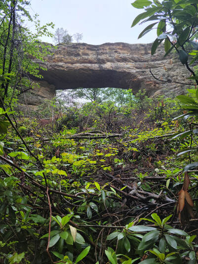
After this the wildlife sign, we just focused on making the hike up the hill to the Natural Bridge. Nice walk in the woods, and the grey, overcast day was really accentuating the forest green. Basically, a nice walk in the woods. We passed a few more CCC shelters and several more hikers coming down the hill and a lot of trees. As we up the trail, we saw more of the rock that made up the ridge and some impressive hanging gardens growing out of the sandstone. Mostly ferns but really interesting how they have rooted themselves into the sandstone wall and survive on the water that is seeping through the rock. Yep, just a nice walk in the woods. And then…
Viola! The Natural Bridge. Our destination for the hike. We came around a bend in the trail, looked up the slope and there it is. The trees and shrubbery above the trail had been trimmed back to allow for a better view from the trail below the arch. We all stopped to snap a photo or two. Glad that I took a photo with the phone as that one was the better compared with the SX50. Phone cameras have come a long way and do a fine job with landscapes, they just lack the zoom I like for looking at critters off in the distance. But the combination of the superzoom camera and the smart phone does work well for hiking. But I digress…
Now that our goal for the hike is in sight, we continued around the last bend in the trail, to get under the huge slab of rock that forms Natural Bridge. Just no way to capture an image of the entire formation from this close as the structure is that big. But it is a marvel to see. We took the trail up into the opening of the arch and just took it all in.
The arches here in Kentucky have a different character that those out in Utah. While made of similar rock and created by the same forces of nature, it seems to me that in general these eastern formations are more angular and rough while those out west seem more rounded and smooth. Differences in the mechanism that eroded the formations, perhaps. The color palate is quite different as well. In Utah, the formations are bare rocks and the sandstone stands out with hues of red, orange and yellow. Here in Kentucky, the formations have more of a grey color but are also covered in lichens and moss as well as highlighted with the green foliage that grows on and around the arches.
Another difference between the formations here in the Red River Gorge area and Arches National Park is that you are allowed to climb on the arches here, well at least some of them. Like Double Arch, there is a trail that leads up on top of Natural Bridge. On the backside of the arch, there is a narrow crack in the rock where steps have been created to allow access to the top. Emphasis on narrow. One-way traffic as there is not room for folks to pass in this gap. Shoot, one person going up this route will scrape on both sides of the rock corridor while passing through.
Rhonda and Chris were already on top when I arrived. They were investigating the photographed options of reflections in the puddles on top of the arch. I started with the views looking out over the forest. Very green below and grey above. There were wisps of fog and mist reaching down into the forest. Sort of a damp and dreary scene, but also lovely as only nature can be. But our time on top of the arch was short-lived as there was a rumble of thunder in the distance so it was time to beat a hasty retreat for the exposed, high ground on top of Natural Bridge. Oscar was just coming up as the rest of us were waiting our turn back through the narrow access route. He did get a quick look around before returning to relative safety under the arch.
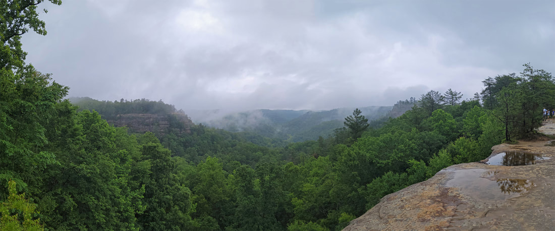
By the time we had gathered under Natural Bridge, it was raining very hard. The weather again moved in more quickly than expected. Looks like another wet hike. Too bad, as it would have been nice to take the trail that continued on from Natural Bridge out along the ridge to the viewpoints. Not today. Being up on the ridge in a thunderstorm is not a good idea. While we were dry here under the natural shelter of the arch, we figured we better get moving back down the hill.
It was a wet hike back. The dense foliage provided some shelter, but we were still soon drenched. My boots were again soaked. Any thought of getting a reprieve from the elements by stopping in one of the CCC shelters were quickly dashed as the first three or four that we came to were full to overflowing with the tourists who had been following us up the trail. So, we just continued with our wet hike, head down and plow through the weather. The final shelter that we passed on our way out had room for us, but by that time were soaked, so no need to stop. The good news was that the rain let up by the time we were back down to the gift store and the temperature was warm so we were not chilled by being soggy.
We stopped in the gift store. This did provide an opportunity to get out of the rain for a few minutes, although by now the deluge had reduced to a sprinkle. The building is sort of a big, open pavilion structure, with a hallway down the center that is open on each end, the gift shop on one side and the restrooms on the other. We all fanned out to see whatever was of interest. I walked down to the end of the center aisle to check out the wooded area at the far end, in case there might be a bird or two hanging out there. There were, a nice the variety in fact and quite colorful: Northern Cardinal, American Robin, American Goldfinch, that I could see and identify, and a few others that were just hidden enough in the foliage that I could not get a good look. There was a woodpecker in the mix as well, based on the flight path it made when it departed the area, but no idea of the exact species. Flicker, perhaps.
I caught up with Lynn in the little gift shop. We found our souvenir pin for the State Park, so that was worth the stop. No hats or shirts of that caught my eye. There were some interesting rocks and fossils, but none went home with us. After the quick spin through the gift shop, we went outside and waited for the gang to reconvene for the hike back to the trailhead. This gave us an opportunity to check out the interpretive signs that provided history of the park (that info is listed on a separate page).
 Northern Rough-winged Swallow
Once back across the swinging bridge, we traipsed through the puddles along the trail. Funny how on the way out we were working along the edges to try and stay dry. Not much point in that now. I just plowed through the middle as I led the pack back toward the trailhead. However, I spotted some birds and had to stop for a photo or two. There was a flotilla of Wood Ducks, mama and a herd of babies. Very cute. Then another bird caught my attention. A swallow of some sort from the shape and the way it flew. Fortunately it was willing to pose for a portrait so I got a couple decent images and was able to later identify it as a Northern Rough-winged Swallow.
The funny part of the hike back was the guy that I ended up talking with while watching the swallow. That’s funny as in “strange” not “LOL.” Anyway, the gang had moved on toward the trailhead and this thirty-something guy ambles by and starts to tell me about the mountain lion that he saw early this morning while driving around on the back roads. Just a fluke sighting as he spotted something big and brown along the side of the road, so he stopped for a look. The big cat was in the ditch along the road but got up and ambled across the road and on its way. That’s a great sighting, as there certainly are not many mountain lions in Kentucky. I’ll trust that is what he saw, as Lynn and I have had odd sightings like that as well (never a mountain lion, at least not yet, but there was that bobcat in the parking lot of our hotel in Moab several years ago).
We were off the trail about 12:15. Not a long trek today, only 2.4 miles but we were our for nearly 2 hours including the time around the gift shop. Yep, soaked again, but we are just minutes away from the cabin where we can get out of our wet clothes and start our boots to drying once again. Those blow dryers are getting a workout this weekend!
Not a lot of photos from the hike today, just a small gallery linked here.
Lynn and I tallied our critters on the way back to the cabin. A short list, and most were seen along the river or near the gift shop, but not bad given the conditions:
|
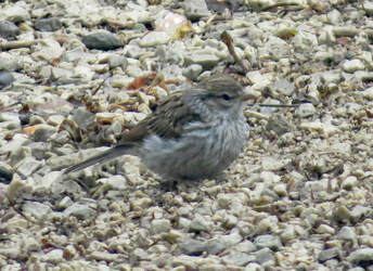
Chipping Sparrow (juvenile)
|
Once we had our gear drying and were cleaned up, we regrouped around the dinner table and snacked the afternoon away. Oscar and I finished the crab and mac leftovers. Like so many excellent meals, this was even better the second day. And of course there was more beer sampling after lunch which lasted well into the evening! While the past couple days focused almost exclusively in IPAs (well, we did squeeze in that one Dragon Fandango), tonight had a little more variety with a couple stouts added to the line-up. Don’t worry, still plenty of IPAs as well!

- Big Bad Baptist Double Chocolate Double Peanut Butter Imperial Stout, Epic Brewing Co. (11.5% ABV): I caught a nice whiff of peanut butter when I opened the bottle but that was the end for peanut butter. Very smooth. Hints of chocolate. Not boozy at all even at 11.5% ABV. Good beer. 4.25 rating on Untappd.
- Fudgement Day IV: Dessert Wars Imperial Stout, Magnify Brewing Company (11% ABV): Chocolate meet beer! A brownie stout. From the first whiff to the last sip this is a chocolate bomb, boy oh so smooth. 4.25.
- Sun Reaper DIPA, Toppling Goliath Brewing Co. (7.8% ABV, 50 IBU): Interesting aroma and flavor. Plenty of fruit notes, but something in there I cannot place. Whatever, still a good beer. Another keeper from TG. 4.0.
- Jet Black Heart Nitro Vanilla Milk Stout, Brewdog (6% ABV): no rating; somehow, I missed this one when entering the ratings. That’s probably not a good sign.
- Axe Man IPA, Surly Brewing Company (7.2%, 65 IBU): I've tried this one before, but since the can was open... 3.75.
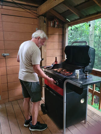
We kept dinner relatively simple with a cookout of sorts. Lynn had brought burgers and brats for the group. We decided that burgers would be sufficient for this evening. Oscar manned the grill, which was on the lower-level deck and I kept him company and acted as the gopher as needed. We were eating in no time. A simple burger never tasted so good. The bonus for tonight was that Donna whipped of a batch of chocolate chip cookies. Outstanding!
After dinner, we continued our travel talks tonight. Chris provided the evening entertainment with slideshows from recent trip. There was the New England trip that Donna, Oscar, Rhonda and Chriss took last fall which included stops at Acadia National Park and several other interesting locations. Lovely fall colors and plenty of old covered bridges. Rhonda and Chris also had an excursion in the Upper Peninsula of Michigan where they seemed to focus on lighthouses. Plus, a southwest tour from Tucson through White Sands. Amazing images in each slideshow. We all carry a camera when we’re out hiking and we all get good shots, but Chris really has a talent for photographer and has a great eye for capturing amazing images.
I spent a few minutes looking at hiking options for tomorrow. Seems that we will finally get a dry day, but the trails will likely be a mess. Sticking with the top ten list and checking the details in the hiking book, I decided on Silvermine and Hidden Arches, combining trails on the same area. The hiking book is soaked but still providing value!
Another fun, albeit wet day, but we are all running out of steam. I think it was about 10:00 when we declared doneness.
Day 4 - Saturday, June 12 - One more hike in Red River Gorge. Once again, I think I was the first one up this morning, rolling out of bed at 0600. I lounged in the downstairs sitting area until about 0800, checking email and playing games on the phone, plus reviewing the hiking plan and weather forecast for today. Looks like we’ll finally get a dry day (knock on wood) so we’ll go for a hike for sure. The Silvermine Arch and Hidden Arch combo that I looked at last night still sounds like a winner for today. The details in the hiking book warned of a section of the trail that is notorious for poison ivy, something we that all want to avoid. But it appears that we can just bypass that area of the trail by walking along the campground road, so no issue there.
Once the activity started upstairs, Lynn and I joined the rest of the group for breakfast. Everyone was in good spirits again today and perhaps even more so with the sun shining in the clear, blue sky. Looks like a lovely day in the making. The morning just flowed from eating to gathering gear to getting on the road. But with the forecast showing a big zero for rain probability, we are in no real rush to have to beat the weather. By 9:30 we were loaded up and heading to the trailhead, so not too bad for a group of retirees, almost-retirees and retires-wannabees.
Less than 10 miles from the cabin to the Hidden Arch trailhead at the inlet of the Koomer Ridge Campground Road, so about a 15-minute drive along the winding roads. The little parking lot was getting full but there was space available for our two trucks. We quickly got our packs, hats and cameras in order, checked the map, figured out were the trail actually started and were on our way. I started my Ramblr track at 9:52.
The plan was to first hike out to Silvermine Arch then, if everyone was up to it, go and find Hidden Arch. Basically two out-and-back trails, each with a looping aspect, starting from the same trailhead. Looks like that would cover about five miles with minimal elevation change. Just depends on the trail conditions as we all want to avoid boot-sucking mud today.
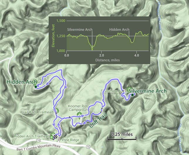
Per plan, we stuck to the campground road for the first part of the hike to avoid the area that was notorious for poison ivy right along the trail. I’ve had my encounters with that plant in the past but nothing like the reaction that Donna had during a camping trip years ago. An ounce of prevention is worth a pound of cure, as the old saying goes, so avoiding the despised plant was our plan.
We walked about three-quarters of a mile from the parking area through the campground to the start of the trail. At some points we could see the trail paralleling the road, but we just stuck to the pavement through the campground where we picked up the trail to Silvermine Arch. However, walking along the road did have some other advantages in additional to avoiding the poison ivy. Of course, walking on a wide but very quiet road allowed us to travel in a little cluster rather than single file, so we could chat a bit more. Then there were the outhouses along the way, which was greatly appreciated by the coffee drinkers in our group. Plus, we exchanged pleasantries with several of the campers who were out and about the area this morning. Looks like a nice campground, with good facilities, shaded campsites and very neat and tidy. There was even a nice-looking gathering spot, and amphitheater of sorts, for evening campfires or other programs. We also had the opportunity to see the variations in camp setups, from bare bones to pretty luxurious. Everything from tents to smaller RVs. Some had their own outhouses there were a couple with outdoor showers complete with solar heated water supplies, although there might not have been much heating over the past couple of days with all the cloud cover. Chris and Rhonda are in the market for a small camper van and ended up talking to a retired couple who had just such a vehicle. Just like hikers, or golfer or mountain bikers, campers are more than willing to talk about gear and experiences, even with total strangers.
We walked about three-quarters of a mile from the parking area through the campground to the start of the trail. At some points we could see the trail paralleling the road, but we just stuck to the pavement through the campground where we picked up the trail to Silvermine Arch. However, walking along the road did have some other advantages in additional to avoiding the poison ivy. Of course, walking on a wide but very quiet road allowed us to travel in a little cluster rather than single file, so we could chat a bit more. Then there were the outhouses along the way, which was greatly appreciated by the coffee drinkers in our group. Plus, we exchanged pleasantries with several of the campers who were out and about the area this morning. Looks like a nice campground, with good facilities, shaded campsites and very neat and tidy. There was even a nice-looking gathering spot, and amphitheater of sorts, for evening campfires or other programs. We also had the opportunity to see the variations in camp setups, from bare bones to pretty luxurious. Everything from tents to smaller RVs. Some had their own outhouses there were a couple with outdoor showers complete with solar heated water supplies, although there might not have been much heating over the past couple of days with all the cloud cover. Chris and Rhonda are in the market for a small camper van and ended up talking to a retired couple who had just such a vehicle. Just like hikers, or golfer or mountain bikers, campers are more than willing to talk about gear and experiences, even with total strangers.

While Chris and Rhonda got their tour of the camper van, the rest of us waited at the trail. We are back in the woods for the hike at to Silvermine Arch, but the trail it dry and well maintained. We soon came to an intersection where we would have joined this trail had we taken the poison ivy path. There was a sign at the intersection pointing back along this path with a familiar symbol. Chris quipped that there was wifi here in the forest based on the image. Very clever, Chris, but I think that sign is pointing the way to the amphitheater!
A short distance past the intersection we got our first critter sighting for the day, and not one that we see that often, an Eastern Box Turtle. He or she was just crossing the trail in front of us, and making good time. Sure, these critters are not speed demons, but they are faster than they are given credit for. But not so fast to avoid the camera. And he was willing to pose for a portrait, so we got a nice image as well.
A short distance past the intersection we got our first critter sighting for the day, and not one that we see that often, an Eastern Box Turtle. He or she was just crossing the trail in front of us, and making good time. Sure, these critters are not speed demons, but they are faster than they are given credit for. But not so fast to avoid the camera. And he was willing to pose for a portrait, so we got a nice image as well.
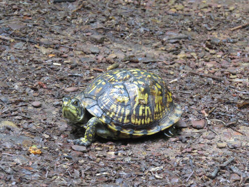 Eastern Box Turtle
What a great day for a hike. The sun is shining, the conditions are pleasant, no rain predicted, the trail is in great shape and the birds are adding their songs for some lovely background music. In fact, there were some interesting songs, so I let the gang get head of me so that I could try to identify who was singing. No way I was going to spot the songbirds in the foliage, unless I got really lucky. The birds are just not as cooperative with photos as the turtle was. But maybe the BirdNET app can help. There was one bird that was singing regularly and close enough that I should be able to get a decent recording. The first attempt the app identified the crooner as a Cerulean Warbler, but tagged the identification as “uncertain.” Wow, that is a beautiful little bird based on the image the app displayed. A little further down the trail, I heard the same tune and tried again, this time getting a “highly likely” identification of a Cerulean Warbler. OK, I’ll go with that. I’ve seen a flew birds flitting about in the trees, but no way to be certain what those are, but the song identification seems conclusive enough. Time to catch up with the group.
While there was a lot of activity in the campground, we saw no one during the hike out to Silvermine Arch. The trail was all ours. After the flat section through the woods, the forest started to thin a bit, then opened up when we reached the start of the steep downhill section. Seems we had been hiking across the top of a plateau and now had reached its edge. We went through a couple short switchbacks then there was a long, straight set of wooden steps to get us down into the valley. OK, that is going to be fun on the hike back. By the time we reached the bottom of the steps, we were back into the deep green of the forest with more of the damp, rainforest feel like when we were hiking along Auxier Branch two days ago. And we were still heading downhill.
The deeper we went, the more like Jurassic Park this seemed. Green and lush. Lots of ferns and mountain laurel. We continued downhill, wondering how much further we had to descend before reaching the arch. The answer to that question was pretty much to the bottom of the little valley. The trail eventually brought us right to Silvermine Arch. This is a massive slab of sandstone, think, wide and long. The opening under the arch is deceptive, so it is pretty wide, but at some points not very high but it gets higher further downhill.
We walked along the formation then crossed under the arch into a big bowl like area. It is sort of a natural courtyard area on the other side of the arch, with high sandstone walls all around. Plenty of moisture here seeping through the rock as there are once again beautiful hanging gardens or ferns and other plants covering large sections of the walls. The arch itself is covered in moss and lichens giving it a lovely green color so that it blends in nicely with its surroundings.
We went to exploring the area. As usual, the guys were all over the place, climbing over the rocks. Chris was investigating all the angles for photography. I could not find any way to capture the entire formation in a single shot, since it was quite large and there was no vantage point that provided the big picture view of the arch. But there was still plenty to see in the area. The bowl around we found once we crossed under the arch was lined with hanging gardens and had several large boulders strewn about. I’m guessing the rocks are the remnants of when this area was one, but sandstone block, before the forces of erosion carved out the bowl and formed the arch.
Views looking under Silvermine Arch from each side.
|
|
|
The bowl was very damp which was the reason for it also being so green here. The hanging gardens covering the surrounding walls indicated that there was a lot of water seeping through the porous sandstone, but there was also a steady rain falling from the upper edge of the courtyard wall down into the bowl. The sunlight shining through the trees was rather harsh so it was tough to get a good photo of these details (funny, we have a beautiful day, but right now the overcast would have been helpful for photography I think). There was a channel running under Silvermine Arch to funnel all the water out of the area. This was not a running creek, at least not at present, but I could see that during a big rain there could be water flowing through. Which brings up a question: is Silvermine Arch actually a bridge? And for that matter, it seems that the Natural Bridge we saw yesterday should be classified as an arch?
The gap under the arch varied in height, getting taller further downhill. Where the channel ran under there was a lot of clearance, so it was very easy to walk under the stone slab. But back up the hill, you had to duck or even crawl to pass from one side to the other. Chris seemed to have missed the memo on this point as he walked right into the low clearance section of the arch, causing a gash on the top of his head. No damage to the rock, but Chris was now bleeding profusely. It wasn’t like he cracked his skull, just a scalp wound and those do tend to bleed a lot. Rhonda got him fixed up using a towel and whatever else was available. My first aid kit was so out of date that I had not even carried with me this week. I guess I’ll have to restock it when I get home. Unlike Humpty Dumpty, Rhonda quickly had Chris put back together again. |
|
Once Chris was tended to and had a little break, we decided to it was time to continue our hike and make the climb back up the hill. Oscar and I kept and eye on Chris, walking behind him, just in case he got dizzy. Fortunately, there were no issues. By the time we got back up to the steps, all was well, and Chris was marching right along.
I took the lead going up the set of steps. My transmission is geared such that it is easier for me to take steps at a good clip. One at a time, and not running but a brisk climb. The girls joked that they were going to take their time and count the steps. OK, I can count and climb at the same time. I think there were 80 steps, give or take.
We passed a group of three or four guys in their early twenties as we reached the top of the steps. They were trail running but had stopped at the steps since we were already coming up and there was no way to easily pass. They just found a shady spot along the trail and waited patiently for us old folks to clear the trail. Turns out there these were the only other hikers that we saw on the trail all day.
The flat section across the plateau gave us a chance to recover from the uphill hike from Silvermine Arch. We continued along the Cliff Trail rather than retrace our steps along the campground road. This route afforded us some nice views out over the forested valley. At one view point there was a shrub sporting large white flowers covering the hillside below the trail. Seek said these were Bigleaf Magnolia. That is an accurate description as the leaves on the shrub were huge. We also saw another Eastern Fence Lizard, appropriately sitting on the fence along the edge of the cliff.
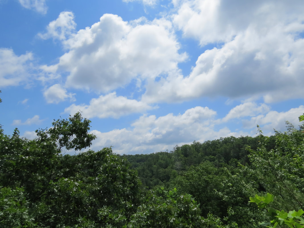
View from the Cliff Trail
|
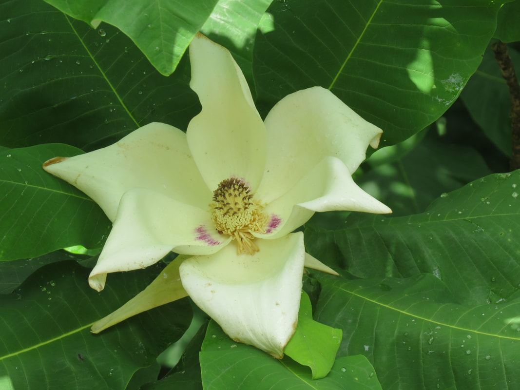
Bigleaf Magnolia
|
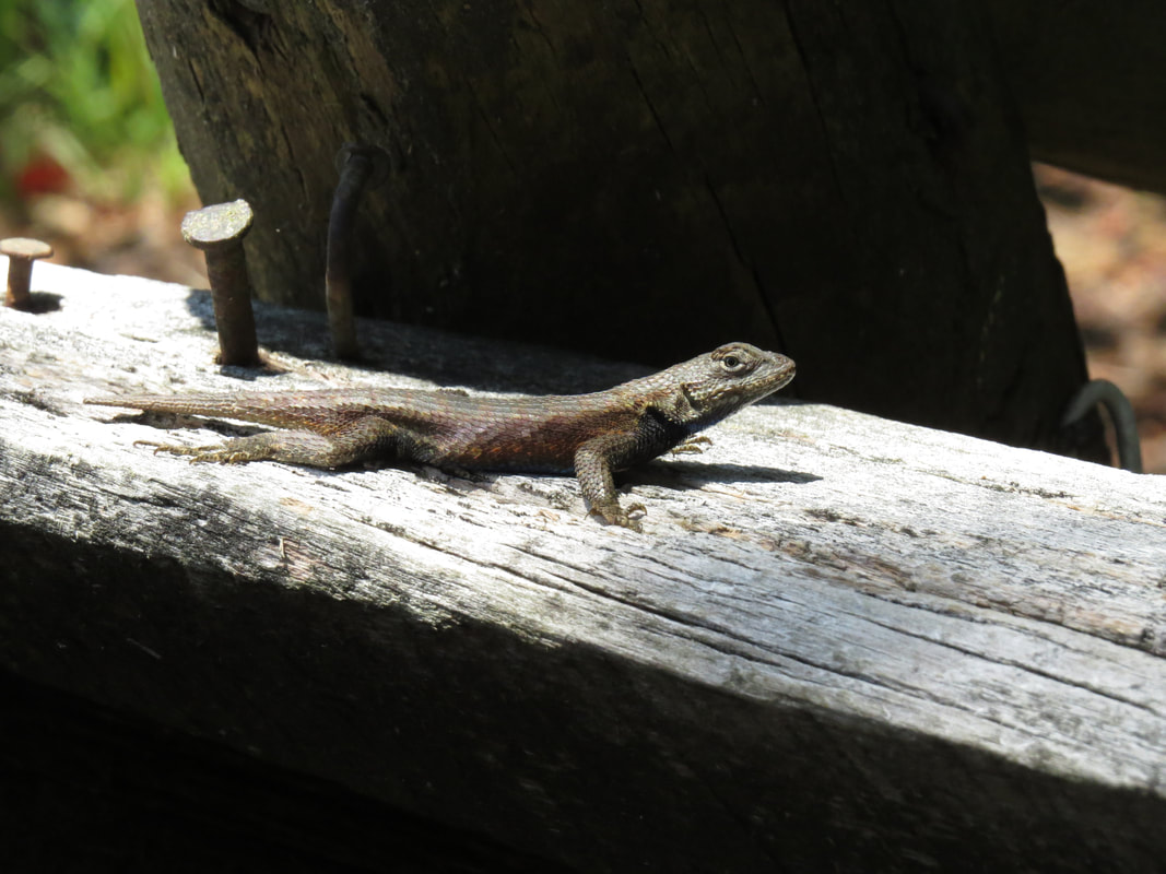
Eastern Fence Lizard
|
The Cliff Trail eventually joined back with the road, just on the other side of the campground so we followed the pavement back to the main road. We stayed in poison ivy avoidance mode and stuck to the road for most of the hike back toward the trailhead, but finally caught a point where the trail was just a couple steps from the road with no shrubs, bushes or other plant life to traipse through. We then ditched the pavement and got back on a good old dirt trail.
We found a little picnic area right along the trail, at the start of Trail 220. The group had been saying they were getting hungry and were ready for lunch and this made for a convenient place to stop. I’ve noticed that Lynn and I seem to be the odd ducks relative to eating during hiking (we’re probably the odd ducks on other points as well). Seems that our hiking buddies all tend to take a lunch break during a hike. That seems to be the case when hiking with this crew as well as with the larger herd out west. Lynn and I general just take trail mix, nut bars (we like Kind and Luna), cut veggies and fruit, and eat as we go. Sure, if we’re hiking to a destination, we may eat when we get there, but it is still just our trail snacks. Our herd mates tend to bring sandwiches or maybe leftovers from dinner the night before and they prefer to stop and have a meal. No problem with that whatsoever, just making an observation of the different styles. Hey, different strokes…
The trail to Hidden Arch is similar to that to Silvermine Arch; a mostly flat hike through the woods except for a downhill section to reach the arch. Not as extreme in terms of the steepness or amount of elevation change, but still enough to get your heart pumping. Just like at Silvermine Arch, the trail brings you right to the base of the Hidden Arch. I reckon it is no so much hidden as well camouflaged. We did see it from the trail above the arch, but we were looking for it.
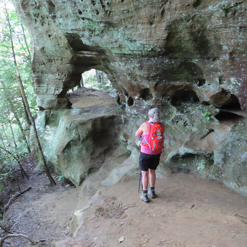 Rhonda sizing up Hidden Arch.
While there were similarities with the trail to the two arches we visited today, Hidden Arch has a completely different character compared to the massive Silvermine Arch. Hidden Arch was smaller and more upright. Really more of a big hole that had eroded through a corner of the sandstone hillside. The face of the rock was full of smaller divots and pock marks, so I wonder if Hidden Arch is the result of several of these smaller features merging over time to create a large opening through the rock face.
I scrambled up onto the ledge that provides access to the arch. Oscar was right behind me. Pretty much the same structure to the formation from either side. The rest of the crew stayed on the trail, which continued adjacent to but below the level of Hidden Arch. Nice view here looking into the forest. Not a big landscape vista but it would be OK for a porch beer view.
Oscar worked his way around the corner of the rock face along. The ledge gets much narrower here, which gave me pause as I’m not a fan of edges with steep drops. But Oscar had found something interesting, so I gathered my gumption and made it over to the recess in the face of the rock. We could see several white sacks for lack of a better term hanging in the recess. The lighting was poor so it was hard to see and even more difficult to get a photo. We studied these for a while and finally determined that these were spider webs that were holding water which was catching the limited light just right to make them look white.
We made our way back around to Hidden Arch. Rhonda was still taking pictures with her phone, but the rest of the group was starting to meander on down the trail. She also moved along as Oscar and I finished our look around then climbed down from the arch. As usual, we were trailing the pack, but there was only one route to go so we had no worries that we would catch them. From the arch, the trail continues downhill for a short stretch then climbs steeply back to the level ground on top the plateau. It was in this area that I heard another interesting bird call, although there was no sight of any little feathery critters flitting about. I whipped out the BirdNET app and it confidently stated that the call was that of Hooded Warbler. Cool, another new addition to the sighting list. I heard the call again a little further down the trail a short time later so got a repeat data point just go make sure. Yep, the app was “almost certain” that this was a Hooded Warbler. I reckon that clinches it.
We caught the group at intersection of the Hidden Arch and Koomer Ridge Trails. We could turn left here a continue the trek in the woods, with the potential to add several more miles to the hike. Or we can turn right and have and easy mile walk back to the trailhead at which time we could call it a day and head back to the cabin. We chose the latter.
While we did encounter a couple more puddles on the return hike, there was nothing that we could not easily work around. In fact, the trails were pretty dry considering all the rain over the past couple of days. Sure, it was damp down around Silvermine Arch, but that is just the way it is there, I bet.
We were back at the trailhead right about 2:00 PM. Ramblr tracked us at 5.3 miles and 2:45 for our time on the trail. The parking lot was full now and folks were squeezing vehicles into the tiniest spots. We quickly stored our packs and got on our way to make room for the next set of hikers. Here's the link to the photo gallery for the Silvermine and Hidden Arches hike.
Another quick stop for ice on the way back to the cabin. The nicer weather has brought out a few more folks as there was more activity at the little convenient store. Nice old pickup truck out for a cruise and a few off-road vehicles getting fuel for an excursion. But we are done for the day, so time to get back to the cabin and relax.
Back at the cabin, we went through the usual process of storing gear and getting cleaned up. The nice part was that our boots were all dry today, so no need to run the blow dryers. Once we completed our chores, showers, whatever, we reconvened around the dining table. I was cleaned up pretty quickly, so I figured I might as well have a beer before we start our final sampling session. I started with an old favorite, a Pompeii IPA from Toppling Goliath. The boys and I started the sampling session about 3:15 and worked on a variety of beers throughout the afternoon and evening.

- When in Rome New England IPA, Missing Mountain Brewing Co. (7.2% IBU): Nice and smooth…almost fluffy. Very good beer. 4.25 rating on Untappd.
- Velvet Robe – Talus, New England DIPA, Missing Mountain Brewing Co. (8.2% ABV): Still digging this beer. Doesn't matter which hops they use, it is a solid hazy DIPA. 4.25.
- Spring IPA, Maine Beer Company (6.5% ABV): Dank. Good. Beer. 4.0.
- Triple Dog Dare Triple IPA, The Brewing Projekt (10.9% ABV): Pretty darn smooth for a triple. Piney, more on the dank side. 4.25.
- The Hazy IPA, Ska Brewing (6.5% ABV, 35 IBU): 3.75.
- Desert Magic IPA, Mudshark Brewing Company (7.2% ABV, 70 IBU): First time drinking this beer outside the state of Arizona. 3.75.
- Me, Myself and Citra, Cushwa Brewing Company (6% ABV, 55 IBU): Not a stellar beer, but not bad. On the lighter side. 3.75.
Another simple cookout for dinner, this time featuring the brats that we brought to share. Don’t worry, Chris, there are plenty of buns. Whatever else was left in the fridge was used for side dishes. It was another grand, yet simple dining experience.
After dinner, we again just chatted the evening away. Somehow, we got into old songs, movie quotes and really bad jokes. But there was a lot of laughing, so it could not have been all bad. We had gone through all the current travel slideshows, so we played “Where’s Allen?” for our big screen photo entertainment. I just scrolled through my gallery of favorite landscape photos while the group tried to figure out where the photo was taken. They did pretty well, as expected with a group this well-traveled in the U.S. Particularly high marks for the National Park locations, but not so much with the few cityscapes. But it was a fun way to pass the evening.
Day 5 - Sunday, June 13 - Heading Home. The really short version for today was got up, cleaned-up, packed-up and headed-out. The reality was not much longer as I rolled out of bed just a little after 6:00 AM and we were on the road by 8:40 AM. Everyone just pitched in with cleaning the house (not really much to do), packing and finally loading up the vehicles. The guys did our normal beer swap. I had a crowler or two from Fat Head’s that we never got to try, so I gave those to Oscar. I came home with a few new brews to sample later as well.
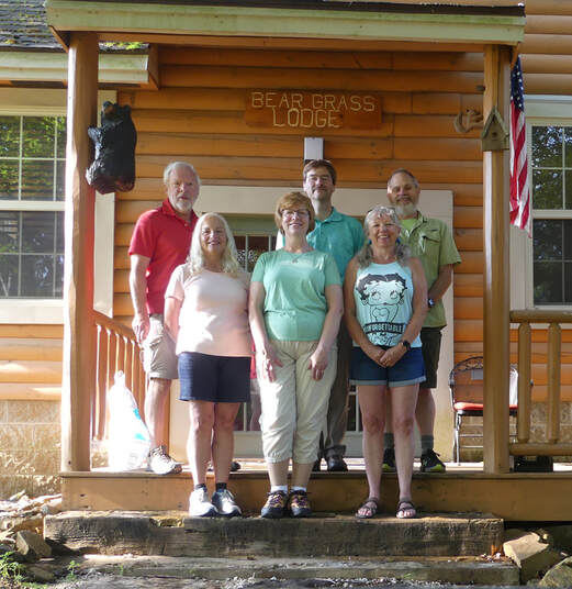 The 2021 Red River Gorge Herd: Donna, Lynn and Rhonda in front; Oscar, Allen and Chris behind.
But it was not all business this morning. The nice thing was that we had a lovely day for the drive back. Very pleasant morning under a bright blue sky. I spotted a few birds in the trees in front of the cabin, including a Carolina Chickadee (identified by call and sighting, although it would not sit for a portrait). That’s a new additional to the overall list. Once we had the vehicles loaded, we gathered on the front porch for our team photo. Nice way to end the event. Then it was a final round of hugs and handshakes and then we loaded up and hit the road.
What a difference the weather made for the trip. It was a much easier drive home under the sunny, blue-sky conditions. If fact, it was a great day for a drive. Just the exact opposite of the trip down to Kentucky. We just enjoyed the views and cruised home. We did spot the Kentucky Horse Park signs. Appears they are open but we opted to save that for another trip. The only stop we made was at a rest stop in southern Ohio after getting through Cincy. The cicadas, or locust as we call them down home, were deafening. We usually don’t hear them until later in July. I hope this is not a preview of coming attractions.
Lynn and the girls were texting back and forth, providing updates on progress of their travels and generally just chatting. I think Lynn is liking her new phone (after years of carrying a simple flip-phone, she finally had to take the plunge into the world of smart phones, albeit kicking and screaming). She’s making the transition. It’s good for her to be better connected. And she’s having fun with it. There was a lot of giggling going on over in the passenger seat. I think the three of them were chatting about their idiot husbands. At least the guys are keeping the girls entertained.
We were back in Medina about 2:30. Lynn suggested stopping at Blue Heron for lunch, since we really did not have any food at home. Works for me. We were between the lunch and dinner crowds, so we had no probable getting a table out on the patio. Lynn had the crab cake and a salad, as I recall. I continued with the splurge from the weekend and had the BBQ pork sandwich and fries. Quite tasty. Of course, since I’m here and this is a brewery, I continued the beer sampling theme and had a flight of Blue Heron Brewing brews:
- OCBA From the Heart, pale ale (5.9% ABV): Copper color, light aroma, Pretty good flavor for a pale ale. 3.75 rating on Untappd.
- Fruit and Fire Cream Ale with Habanero peppers, (5.6% ABV): Definitely fruity. I get the peach and apricot for sure. Heat comes late but is not over the top. Very complementary set of flavors. 3.75.
- Dibs on Nibs Milk Stout, (6.7% ABV): The aroma had me thinking this would be a chocolate bomb, but there was not much in the flavor. In fact, the flavor was lacking overall. 3.25.
- Stuck in the Clouds DIPA, (9.6% ABV): Very sharp (second time trying this one; did not care for it as much the second time around). 3.5.
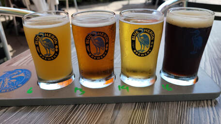
We had a nice relaxed time on the patio overlooking the opening hole of the now defunct golf course but did not sit too long. We were home about 4:00 and got into the post-trip chores of unloading and unpacking, following a check of the cats. All is well at the ranch.
That was a fun little get-away, but it is nice to be home….and dry!
Final Tallies - Numbers & Lists. Yeah, I know, this trip was all about visiting with good friends and exploring an area of the country that none of us had visited. But I can’t help myself, I have to have some numbers to play with and have to compile a few lists to make the trip complete.
- This was a road trip so I reckon I should list the miles we put on the Edge. Just the drive from Medina, Ohio, to Rogers, Kentucky, and back, since we rode with Oscar and Donna while in Kentucky. We’ll call it 719 miles, based on Google maps (give or take a mile or two).
- Hiking miles: 14.7 miles
- Auxier Ridge – Double Arch Loop: 7.0 miles
- Natural Bridge: 2.4 miles
- Silvermine Arch & Hidden Arch: 5.3 miles
- No time in the National Parks for this trip but we were in the Daniel Boone National Forest. Plus, the better part of a day in a Kentucky State Park, the Natural Bridge Resort State Park.
- Critter Sightings. You never know what to expect with animal sightings when visiting any given area. This ain’t Yellowstone, so the herds of megafauna were not expected. In fact, I don’t recall seeing any big animals in Kentucky. But we did much better than expected with the little guys with 34 species that we could reasonably identify (at least close enough for government work). This included spotting a lot of birds (19 different species, including four new additions to our sighting list).
|
Mammals:
|
Birds:
|
|
Bugs & other crawly things:
|
- Beer: We did a lot of sampling over the course of four evenings, tasting at least 25 different beers, 21 of which I had not tried previously. There were 16 breweries represented in this mix.

- Journal pages: 33
- Final photo tally: 496
And in Conclusion…. As usual, that was a lot of fun, even if the weather wasn’t always ideal. This group is great at adapting and going with the flow. A very easy group to please; go for a hike, have a beer or glass or wine, grill something for dinner, go to sleep then get up and do it all again… lather, rinse, repeat.
Red River Gorge made for a outstanding place to visit for a hiking trip. I think a couple more days for this trip would have been great so that we could have explored a more of the hikes on the top ten list. But we got the flavor of the area. While we won’t be in a rush to return, since there are a lot of other places we want to visit, but I would certainly come here again. Maybe a trip that includes a stop at the Kentucky Horse Park, since Lynn has always wanted to go there. Hey, always looking at options for a future trip.
Oh, by the way, it DID rain in Cortez when we were there in the fall. An overnight downpour. The sound of the rain on the metal awning woke me up during the night. No real impact on the hiking the next day as the desert quickly drinks the water. But our streak of rain at these mini-meet-ups remains intact. Just sayin’….